#GranCanariaWeather

As Gran Canaria and the Canary Islands prepare for a Springtime shift in weather conditions, the Spanish State Meteorological Agency (Aemet) has provided a comprehensive forecast for the coming days, indicating a departure from the warm and dry winter experienced so far this year. The latest updates warn of the trajectory of an Isolated High-Level Depression (DANA) that’s moving towards the archipelago, promising varied weather conditions across Gran Canaria.  Yellow warnings are in place for coastal phenomena and winds gusting up to 70km/h in some places.


Weather Overview for the Canary Islands

After one of the warmest, dryest winters since 1961, the Canary Islands are this weekend expecting a change in weather patterns due to the approach of an Atlantic high-level depression. This system is expected to cause showers starting Thursday, especially on the northern parts of the islands, heralding the onset of a wetter period leading up to the Easter Holy Week. The shift is anticipated following a very warm spell last weekend, succeeded by the return of the trade winds on Monday, which has brought a notable thermal drop towards temperature values more typical for this time of year, with a slight presence of calima that started to subside by Tuesday.

 Weather Summary from Wednesday to Monday

Yello advisory warnings for Coastal Phenomena, strong waves, and winds gusting to 70km/h

  • Wednesday: The islands will experience predominantly cloudy skies on the northern slopes, with clearing expected by the afternoon. The rest of the regions will see partly cloudy skies with high clouds. Weak and occasional rains are not ruled out in the northern slopes of the mountainous islands towards the end of the day. The calima will persist slightly in the eastern islands, affecting high levels. Temperatures will see little change or a slight decrease, with moderate northeast winds, strong at intervals, and possibly very strong gusts in the southeast and northwest slopes of the mountainous islands.
  • Thursday to Sunday: Starting Thursday, the arrival of the DANA will markedly change the weather, increasing the likelihood of locally intense showers, particularly in the northern parts of the higher islands. This trend continues into the weekend, with cloudy skies and precipitation across the entire archipelago, notable for moderate showers in the north that could lead to significant accumulations. Temperature drops are expected, particularly in the northern half, with a slight chance of increases in the south and southeast.
  • Monday: While uncertainty remains for the diverse scenarios projected by Aemet, skies are likely to remain cloudy, especially in the northern strip, with possible precipitation decreasing over the day, leading to clearer skies and a slight rise in temperatures.

 Wednesday Forecast for Gran Canaria and Key Islands

  • Gran Canaria: The north will see cloudy intervals, with a low probability of weak and occasional rains in the early morning and late afternoon, especially in the midlands. The rest of the island will be partly cloudy with some high clouds. Temperatures will remain stable along the coasts and slightly decrease inland, with possible moderate drops in the southern highlands’ maximum temperatures. Winds from the north to northeast will be moderate, with strong intervals and a chance of very strong gusts on the western and southeastern slopes, particularly by late evening when winds intensify and could also affect the peaks.
    • Las Palmas de Gran Canaria: Night time Minimum 17°C, Daytime Maximum 22°C (in the shade).
    • Puerto Rico de Gran Canaria: Night time Minimum 16°C, Daytime Maximum 24°C (in the shade, much hotter in direct sunlight)
  • Tenerife, La Gomera, La Palma, El Hierro: These islands will experience similar conditions with intervals of cloudiness and chances of weak, occasional rains, particularly in the northern and eastern parts. Temperatures will see slight to moderate decreases in inland areas while remaining stable along the coasts. Moderate northeast winds with strong intervals and a chance of very strong gusts are expected, especially in mountainous and exposed areas.
  • Lanzarote and Fuerteventura: Will have partly cloudy skies with the possibility of occasional drizzle, especially in the central hours. Temperatures will remain stable along the coasts and slightly decrease inland. Winds from the north to northeast will be moderate to strong, with a chance of very strong gusts, particularly in exposed areas and during the late hours.

Rain Impact on Gran Canaria’s Tourist Beaches

The anticipated weather changes, characterised by rainfall and cooler temperatures, particularly in the northern parts of the islands, may impact outdoor activities, including those on the tourist-favored southern beaches of Gran Canaria, where a 100% probability of rain is currently forecast. While the south may experience less intense weather conditions compared to the north, visitors should prepare for potential rainfall and cooler temperatures. The forecast is evolving on a daily basis.

#GranCanariaWeather Forecast

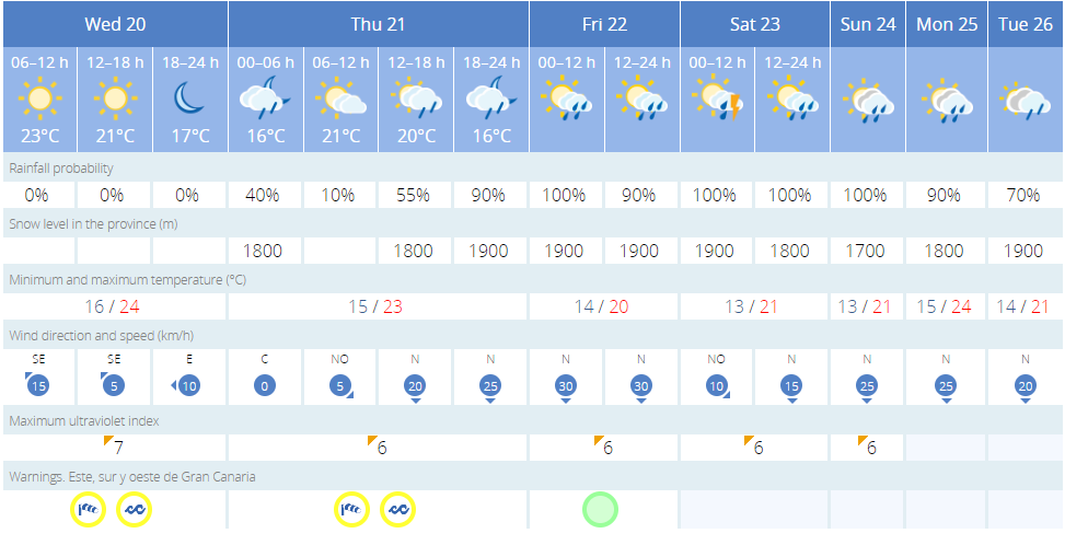
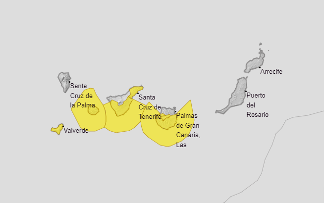
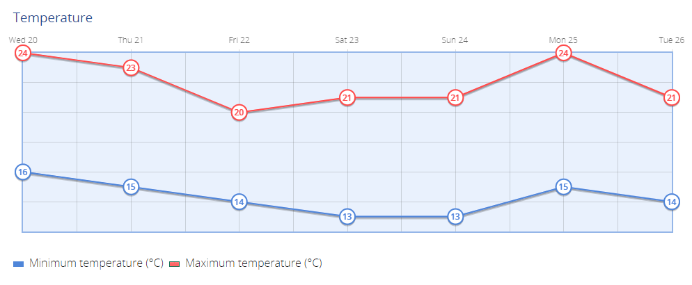
Overview: After a weekend of warm temperatures, a significant weather system is set to impact the Canary Island over the coming days. An Isolated High-Level Depression (DANA) is forecasted to bring cloudy skies and showers, especially to the northern and mountainous areas of the island, starting Thursday. This weather phenomenon follows a return to normal temperatures following the weekend’s heat, with the potential for more substantial precipitation towards the end of the week.

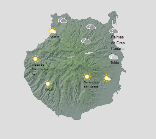
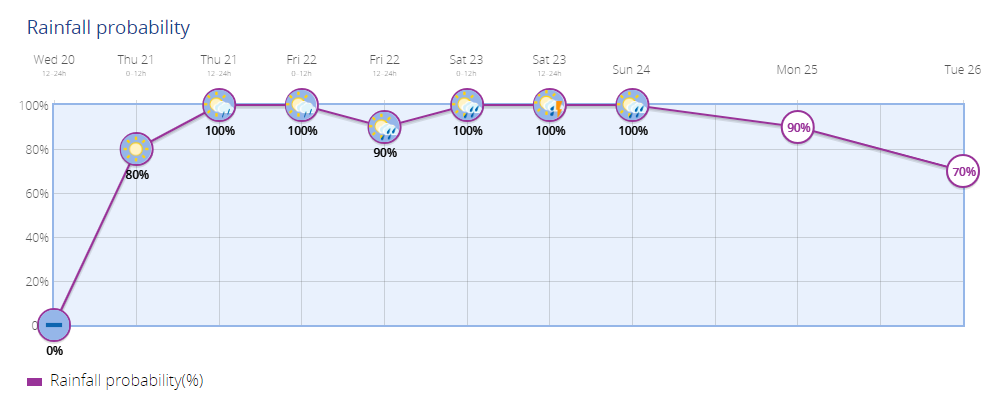
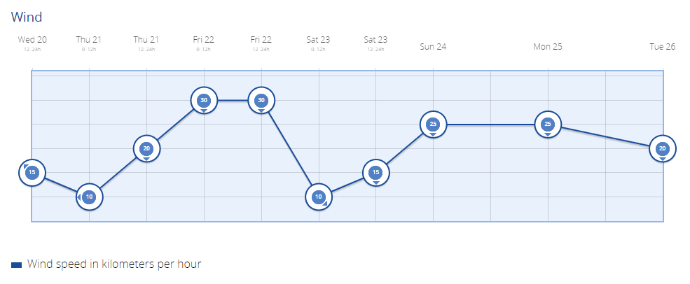
Wednesday: Today’s weather sees a mix of cloud cover across Gran Canaria. The northern regions can expect intervals of clouds with some breaks in the afternoon, while the rest of the island will experience clearer conditions. There’s a slight chance of light rain showers towards evening, particularly in the mountainous areas. Temperatures will remain relatively steady, with a moderate northeasterly wind blowing across the island, occasionally gusting strongly in certain areas.

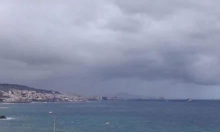
Thursday and Friday: As the Isolated High-Level Depression makes its presence felt, Thursday and Friday are likely to bring more significant changes in weather. Cloudy skies and showers are expected, particularly in the northern and elevated regions of Gran Canaria. Temperatures may experience a slight decrease during this period, and visitors are advised to prepare for potential rain showers and cooler conditions.

Weekend: Saturday and Sunday continue the trend of unsettled weather, with overcast skies and scattered showers forecasted across the archipelago. The northern areas may experience more intense precipitation, leading to possible accumulations. Temperature fluctuations are expected, with cooler conditions prevailing in the northern regions and possibly warmer temperatures in the southern and southeastern parts of Gran Canaria.

Next Week on Gran Canaria: As the weekend draws to a close, Monday’s forecast remains uncertain, with cloudy skies persisting, particularly in the northern regions. Showers are possible but expected to diminish as the day progresses, potentially giving way to clearer conditions and a slight increase in temperatures.  For now things look unsettled, but next week is expected to return to expected norms with blue skies and sunshine across the south.

Overall, Gran Canaria’s weather outlook suggests a shift towards more unsettled conditions, particularly favoring the northern and mountainous areas of the island.