After experiencing an unusually warm start to October, the Canary Islands are set to witness a significant change in weather conditions starting next week.
|
----- Google provide a way for you to
|

Last Days of Heat
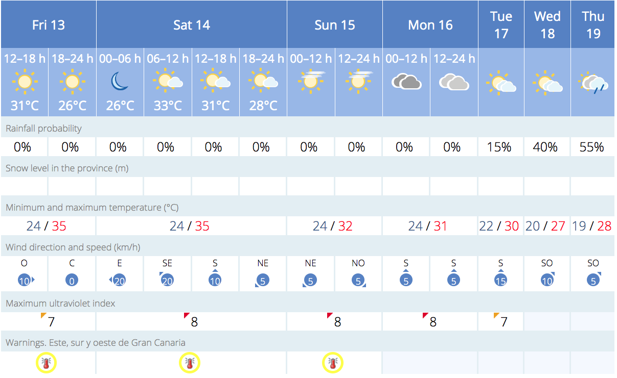
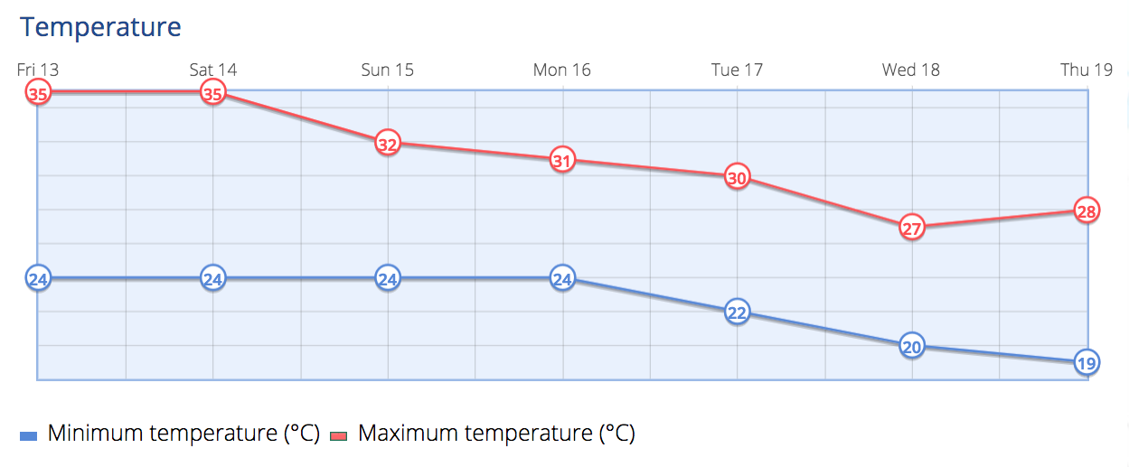
Gran Canaria, along with Tenerife, Lanzarote, and Fuerteventura, is currently under a yellow weather warning for high temperatures, which will continue through Saturday, October 14. Temperatures in specific areas, including the south and east-west basins of Gran Canaria and Tenerife, could exceed 34°C.
Health warnings have also been extended in several municipalities, including Mogán, La Aldea de San Nicolás, and Santa Lucía de Tirajana, which are under a red alert for health risks due to heat until Saturday.
Changes Ahead
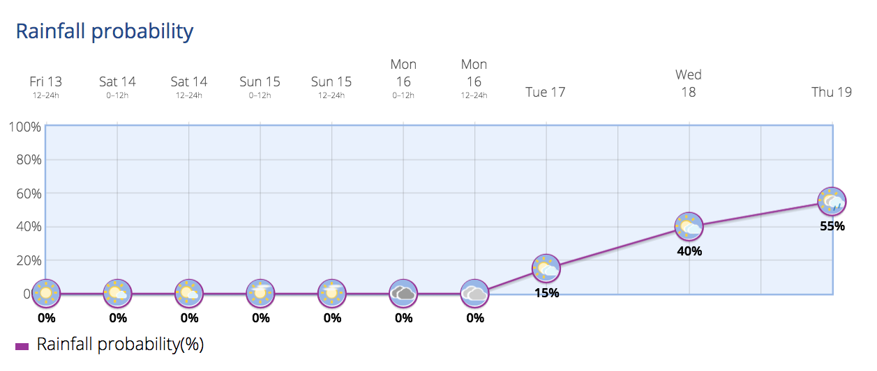
The European Centre for Medium-Range Weather Forecasts (ECMWF) predicts that starting Tuesday, October 17, an Atlantic front will affect the Canary Islands. This is expected to bring abundant rainfall and a noticeable drop in temperatures. The State Meteorological Agency (AEMET) corroborates this forecast, noting the likelihood of cloud intervals and precipitation, particularly in islands with higher elevations.
Meteorologists advise that while these forecasts are still subject to change, current models indicate that the rainfall will intensify by Wednesday, October 18, and continue until at least Friday, October 20. These days could see the highest accumulation of rainfall.

Temperature Drop and Atmospheric Shift
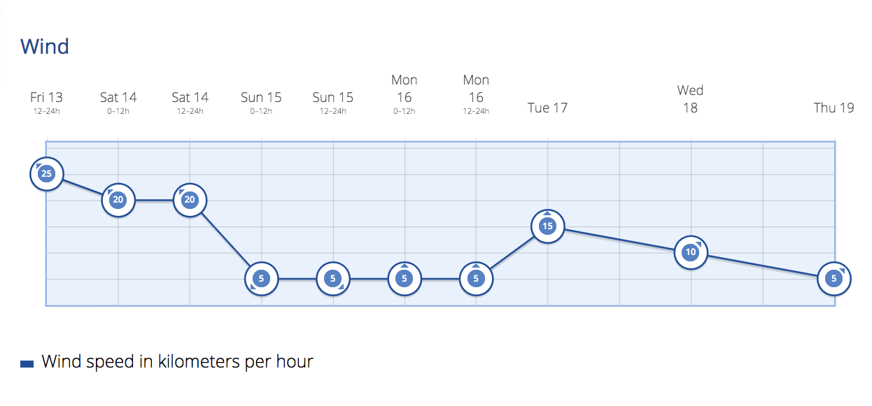
The temperature is expected to normalise, with most areas of the Canary Islands experiencing between 16-22°C. In mountainous regions, temperatures could fall below 10°C. This change will also mark a shift from dry and warm conditions to a cooler and more humid environment, driven by winds from the west-northwest.
Official Recommendations
As the heatwave persists over the weekend, residents are advised to:
– Stay Cool: Spend time in shaded or air-conditioned areas.
– Limit Physical Activity: Avoid outdoor sports during peak hours.
– Stay Hydrated: Drink water regularly and avoid caffeinated, alcoholic, or sugary beverages.
– Eat Light: Opt for meals that replenish lost salts due to sweating.
While residents continue to cope with the ongoing heatwave, the anticipated Atlantic front is expected to bring a welcome change, introducing cooler temperatures and rainfall across the Canary Islands.
Forecast For The Next Few Days
Saturday:Expect clear skies with occasional high clouds. A light haze, Calima, will persist. Temperatures will remain stable or slightly rise, reaching up to 34°C in the midlands and western and southern slopes. Other areas will see temperatures between 30-32°C, except for the mountain peaks. Minimum temperatures will hover around 23-25°C along the coast. Winds will be light to moderate from the east, becoming more intense in elevated areas during midday.
Sunday:High clouds will cover the sky, with some medium-level clouds appearing in the afternoon. Light Calima conditions continue. Maximum temperatures will slightly to moderately decrease, but remain similar to Saturday’s—up to 34°C in the midlands and western and southern slopes, and 30-32°C in other areas. Minimum temperatures will be stable around 23-25°C along the coast. Light winds will prevail, mainly sea breezes.
Monday:Overcast conditions will feature medium and high clouds, which may clear up in the afternoon. There’s a low chance of light rain in the northern parts of the western islands by day’s end. Expect temperatures to slightly to moderately drop, especially in the eastern islands. Temperatures will generally range from 28-30°C, with isolated areas reaching 32°C in the southern slopes. Winds will be light and variable, becoming moderate from the west by the evening.
Tuesday:Cloudy intervals will dominate in larger islands, particularly on the northern slopes during the first half of the day, accompanied by possible light rain. In Lanzarote and Fuerteventura, skies will mostly remain clear with a low chance of light rain. Temperatures will continue to fall, especially in mountainous islands. Moderate westerly winds will be stronger on the northern and southern slopes of mountainous islands. In high peaks, expect strong westerly winds.
Midweek Onwards:For the Canary Islands, expect intermittent clouds and likely precipitation, especially in larger islands. Winds will come from the west and northwest, bringing declining temperatures. Conditions will become more unstable, with cloud intervals and precipitation becoming more probable in the north. Temperatures are expected to either remain stable or show a declining trend during the initial two days of this period.
Stay tuned for more updates and take necessary precautions for changing weather conditions.