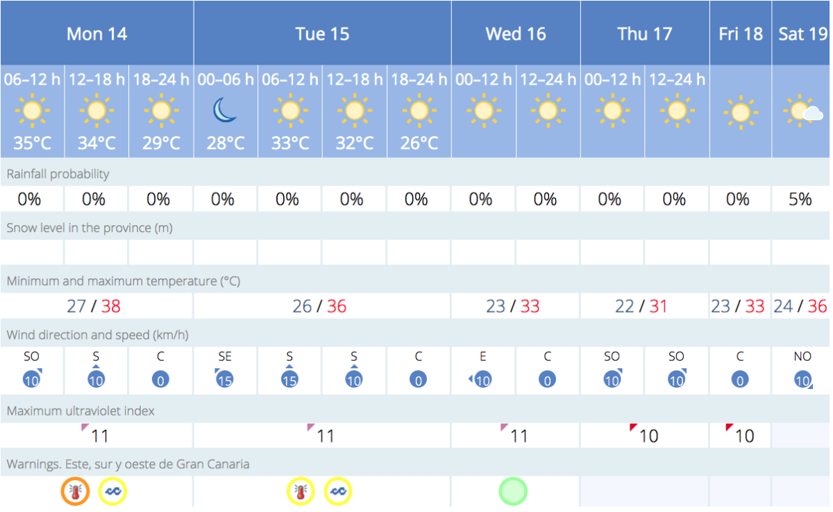
This Monday starts mostly clear with a little cloud along the northern coasts of Gran Canaria, where some medium and high-level clouds may remain until midday, returning again towards the later hours. This is now the fifth day of intense heatwave, though starting to ease a little.
|
----- Google provide a way for you to
|


Calima continues to bring dust in from the Sahara, out to the east of us, primarily affecting higher-altitude areas. However, the phenomenon is expected to subside a little through the day.
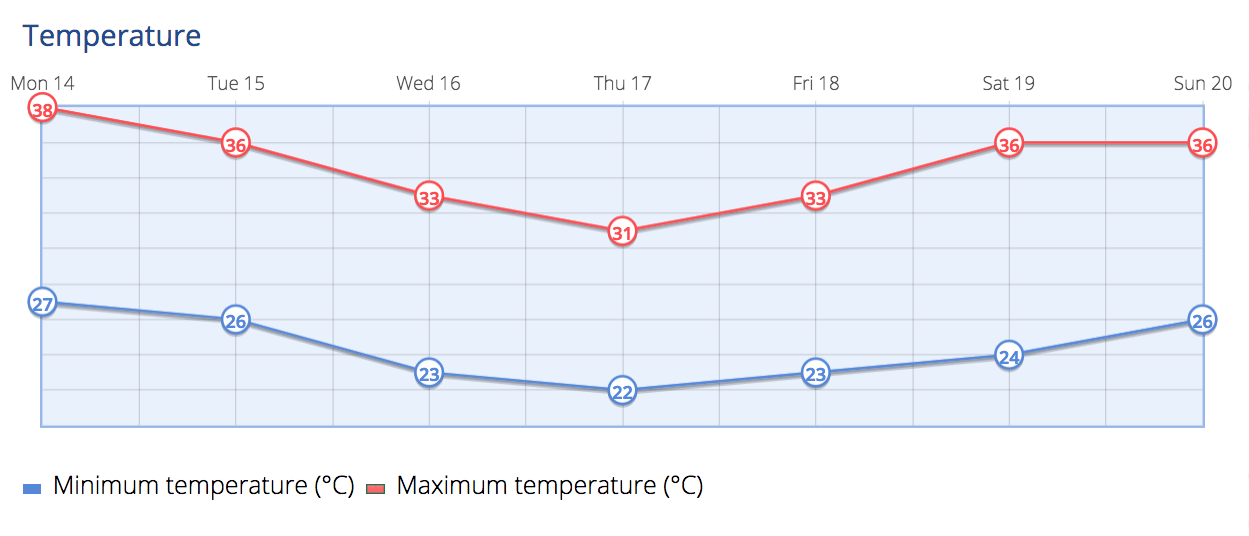
Temperature, according to Spanish State Meteorological Agency AEMET will remain relatively stable along the coasts, with few changes in the south. Inland areas will experience a slight to moderate decrease in the temperatures seen over recent days. Despite the drop in temperatures, there is still an Orange advisory warning in place for Monday on the south, and a Yellow advisory for Tuesday.
Some areas on the southern and western slopes may still exceed 38ºC, in the shade, locally. Generally, maximum temperatures are predicted to be above 34-36ºC in these regions, much hotter in direct sunlight. The north of the island, and in the capital Las Palmas de Gran Canaria will see a little more cloud, with what is known as the Panzo del Burro (Belly of the Donkey) and temperatures may vary by up to 10ºC cooler than on the south.
Minimum Temperatures Overnight might still surpass 28-30ºC in mid-altitude areas.
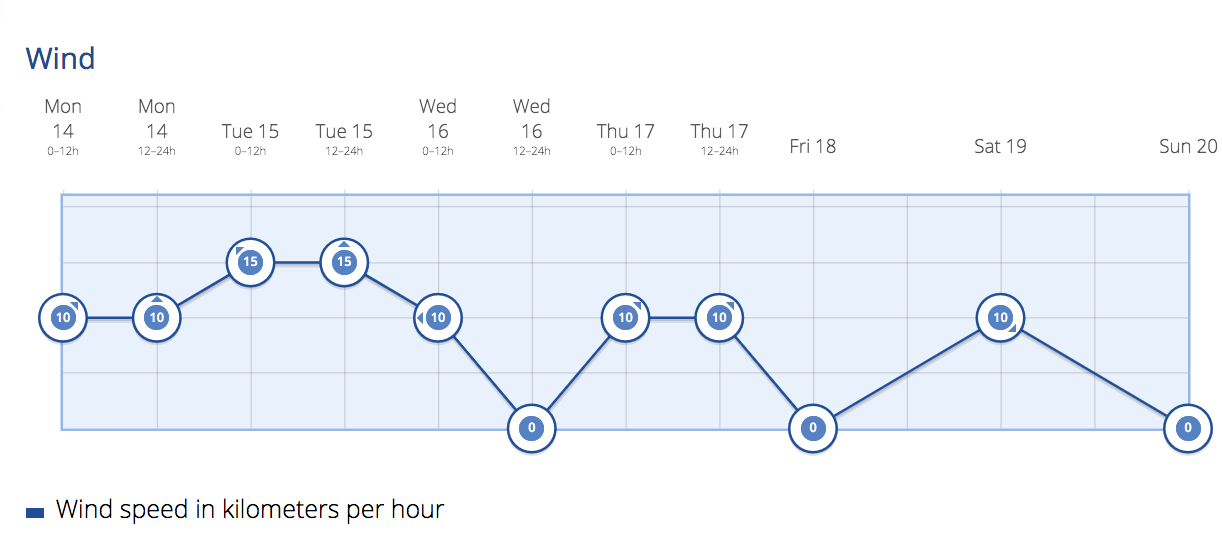
The winds will be coming from the northeast. There will be intervals of strong wind, and there is a low probability of occasional very strong gusts, particularly on the southeastern and northwestern slopes, as well as on the western side of the island.
Coastal breezes expected along the southwest.
On Tuesday the skies are expected to be mostly clear or partly cloudy, with occasional intervals of low clouds in the north. These clouds will become more compact towards later hours. There will be a slight calima still present at higher altitudes.

Temperatures will see a downward trend with maximum temperatures in the shade still reaching up towards 35 to 37 ºC on the southern and western slopes.
– Overnight lows might drop to 26-28 ºC in the southern mid-altitude regions.
– Wind will be coming from the northeast direction with intervals of strong wind. There’s a low probability of occasional very strong gusts on the southeastern and northwestern slopes, as well as the western tip. Breezes will be felt along the southwest coast.
On Wednesday mostly clear or intervals of clouds in the north during the first half of the day and towards the later hours. Slight calima will be remain at higher altitudes, mainly affecting the eastern islands.
Temperatures remain mostly stable though may well experience a slight to moderate decrease with maximum temperatures in the shade reaching up towards 34ºC, but only in interior southern areas of Gran Canaria.
Winds will be coming from the northeast with intervals of strong wind on the southeastern and northwestern slopes. On the summits, the winds will decrease and shift to the northwest
By Thursday the sky will be mostly clear, except for some intervals of clouds in the north during early morning and late hours. Slight calima will still be present at higher altitudes, primarily affecting the eastern islands.
Temperatures will experience minimal changes. Maximum temperatures may locally reach 32 – 34 ºC in the shade on the southern and western slopes of Gran Canaria.
Winds will be coming from the northeast with intervals of strong wind on the southeastern and northwestern slopes. On mountain summits, there will be light variable winds.
As we round off the week, heading into Friday intervals of cloud are predicted to the north with predominantly clear skies due to the Alisios winds from the northeast.
Temperatures may rise again initially and then decrease towards the end of the day.
These predictions provide a general overview of the weather conditions, and local variations might occur. It’s advisable to stay updated with local weather forecasts for the most accurate information.
It remains important to stay hydrated and take necessary precautions to manage the heat. Look out for pets, the young and the elderly, take care of yourselves and each other
-
- Weather for the week ahead on the south of Gran Canaria

-
- Weather for the week ahead in the capital.