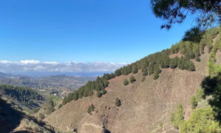
The Spanish State Meterological Agency, AEMET, has issued yellow warnings for heat, calima haze and strong winds this week on the Canary Islands forecasting high temperatures of up to 34ºC expected on several islands. An alert has been issued due to a risk of forest fires on Gran Canaria as the mix of dry weather, strong winds and high temperatures has led to concerns over coming days.
|
----- Google provide a way for you to
|

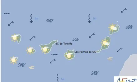
By Thursday, we are expecting yellow advisory warnings for wind to be activated again in Gran Canaria, La Gomera, El Hierro and La Palma, with gusts of up to 70 km/h and affecting summits, as well as southeast and northwest slopes. The Calima will also be evident on the other islands with a liklihood of 40 to 70%, and visibility reduced to just 3000 metres in some places, affecting mainly the summits and medium-high areas of the south, east and west.


The Government of the Canary Islands declared a state of alert for the risk of forest fires on Gran Canaria above 1000 meters in the northern area of the island, and above 400 meters in the east, south and west areas.
The predicted weather for Wednesday and Thursday is also showing clear blue skies with calima arriving from midday on Wednesday, and temperatures expected to rise, especially on the southern slopes. Winds will be from the northeast with strong intervals in the afternoon affecting the summits and southeast and northwest slopes. On Thursday, temperatures will once again reach up to 34ºC on Gran Canaria and Fuerteventura, with 36ºC predicted for the beaches of Maspalomas and Puerto Rico de Gran Canaria, and winds will be very strong, particularly inland at the summits and on the south, east and west slopes of La Gomera, El Hierro, Gran Canaria and La Palma. Though, being in the lee of the island, only light breezes are expected on the south west coast of Mogán, adding to the heat, while Calima haze will remain.

The Calima dust is expected to last throughout the day on Thursday. It will mainly affect summits and mid-altitude areas on the south, east, and west-facing sides of all the islands. AEMET has issued yellow warnings for Gran Canaria and Fuerteventura on Thursday, starting at 10:00 and ending at 20:59, for maximum temperatures predicted to reach 34-36°C, in the shade, with the potential to feel much hotter in direct sunlight, mainly affecting the interior zones of the south and west-facing sides of both islands. The Government of the Canary Islands declared a forest fire risk alert above altitudes of 1,000m in the northern area of Gran Canaria and above an altitude of 400m in the east, south, and west zones.
On Friday, clear or mostly clear skies are expected with “calima” mainly affecting mid-altitude and high-altitude areas, tending to clear up in the afternoon on the eastern islands. Minimum temperatures will remain unchanged, maximum temperatures will decrease slightly, and may become locally moderate. Temperatures of between 30-32°C, in the shade, are expected in mid-altitude areas of the islands, especially on the south and west-facing slopes, with 34°C still likely on Gran Canaria. The winds will be moderate to strong from the northeast, with an eastward component in mid-altitude and high-altitude areas. There is a possibility of strong gusts in the southeast and northwest-facing slopes and summits until the end of the day.

As we head into the weekend, there will be clear or mostly clear skies for the northern regions of the islands, becoming partly cloudy during the morning. There may still be “calima” at high altitude over the western islands during the first half of the day, and temperatures will generally decrease, although temperatures may still reach 30°C, in the shade, in mid-altitude areas on the south and west-facing slopes of Gran Canaria. The winds will be moderate to strong from the northeast, intensifying by the end of the day, with probable strong gusts on exposed summits and slopes, as well as in mid-altitude zones of Lanzarote and Fuerteventura.