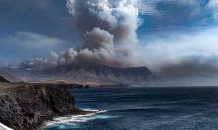
A cold front is expected to arrive on The Canary Islands by Thursday bringing a drop in temperatures this week and we may see significant rainfall before the weekend. A storm, currently near the British Isles, is expected to influence the formation of a deep Atlantic trough that is predicted send a “Polar Jet” of cold air that could reach the Canary Islands, if forecasts are correct.
|
----- Google provide a way for you to
|
The Spanish State Meteorological Agency AEMET point out that there is “a margin of uncertainty” regarding predictions for a drop in temperatures by Thursday, February 4 but that “it is likely that a centre of low pressures will be isolated to the west or southwest of the Peninsula, affecting the Canary Islands”. The resulting precipitation is expected to be abundant on the Canary Islands, and may be “locally strong or persistent” to the north of the higher altitude islands. Snow is possible on the summits with the drop in temperatures. Everything will depend on how the cold front develops throughout this week.

Monday
To the north, below about 700 to 800 meters, intervals of low cloud are expected, which by the afternoon will give way to intervals of high cloud. Clear skies elsewhere, tending toward intervals of high cloud in the afternoon. Temperatures may rise slightly, more pronounced on the southern slopes of the island. Moderate northeast winds with strong intervals during the first half of the day on southeast slopes, northwest and at the summits. Predominance of breezes on the southwest and northeast coasts.

Tuesday
Cloudy skies with high cloud, and intervals of low cloud to the north, below about 700 meters, from the early morning. Temperatures unchanged though perhaps slightly decreasing. Northeast winds, which will decrease from noon, prevailing breezes on the coasts from the south and in higher areas. During the first half of the day, breezes on the southwest and northeast coasts.

Wednesday
Cloudy intervals in the morning, becoming clearer through the day with some intervals of high cloud. By the end of Wednesday, cloudy skies will start to appear from the west, likely to bring weak rains in our direction. Temperatures will stay pretty constant on the coasts, with a slight to moderate decrease inland. Winds from the north on the coasts and inland areas, which will tend towards a moderate northwesterly; at the summits, with strong intervals from the west/southwest in the second half of the day.
Thursday
On the eastern islands, cloudy intervals will tend towards rain by the second half of the day, mainly to the north of Gran Canaria. Rainfall is likely to be accompanied by occasional storm weather, especially in the second half of the day. Falling temperatures, could be more noticeable in inland areas. Winds from the west to northwest, which could become stronger inland and at the peaks, where gusts are not ruled out.

Friday
Snow is possible above the 1500 m on the Canary Islands, intense rainfall will continue, which could be locally persistent on and occasionally be accompanied by storms. Temperatures set to drop by several degrees in the Canary Islands. Winds from the north, with a westerly component and very strong gusts expected.
Weekend
Low pressure between the Canary Islands and the southwest of mainland Spain will tend to move towards the east. Wet weather and instability on the Canary Islands may will continue through the weekend, with rainfall expected to be less intense than over the previous couple of days and will tend to subside. Temperatures will start to rise again on the Canary Islands, though winds continuing from the north, with the potential for very strong gusts on the higher altitude islands, trade winds likely to bring further rainfall to the north of the islands as temperatures tend to continue to rise towards seasonal norms.