From Saturday strong winds are expected to reach Gran Canaria with very strong gusts from the east intensifying on Sunday, and possibly exceeding 80-100 km per hour, particularly in high altitude and inland areas they could potentially exceed 120 km/h .
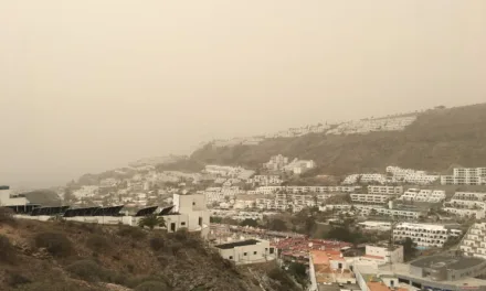
The winds from the east component will very likely bring quite thick blankets of African dust suspended in the air over the islands leading to a significant reduction in visibility throughout most of the archipelago, possibly to below 1500 meters in some places.
AEMET have also highlighted the likelihood of rough seas, especially on Sunday morning, with east winds of force 7 in coastal areas.

Day time temperatures are expected to climb up to 29ºC in the shade, possibly higher in direct sunlight, though with calima this heavy that may not be an added complication.

The situation looks likely to continue at least until Monday 24, when wind conditions will tend to decrease in intensity from the afternoon, and thereby improve the situation at sea, although there is a distinct probability of strong winds, high temperatures and dust continuing on into next week.
The Government of the Canary Islands, through the General Directorate of Security and Emergencies, have declared an official Wind Alert in the Canary Islands, starting from 9:00 pm on Saturday February 22.
The decision was taken following information provided by the State Meteorological Agency and other available sources, and so the “Canary Islands Emergency Specific Plan for Risks of Adverse Meteorological Phenomena (PEFMA)” as been activated.
Observations: Strong east and southeast winds, average speeds 30 – 60 km/h, with locally stronger intervals during the early hours of the morning. Maximum gusts of 80 – 120 km/h, with potential for stronger gusts in some areas. The most affected areas will be northern and western municipalities of the most prominent islands, inland areas and the highlands of eastern and southern slopes, and the summits.
Everyone is asked to be careful when out and about, and in particular check to ensure that loose items on terraces and other parts of your property to not pose a danger to others during this weather event.


The Canary Guide
Advertise your business to English Speakers on Gran Canaria
We have a range of exciting advertising opportunities starting from as little as 2€ a day online, having been in print for ten years we are now moving towards English language video and television, and with a regular audience reach of more than 50,000 people every week, 15-20,000 individuals come to our website every month 2-3 times a month.
Contact us by email on [email protected] for more information