

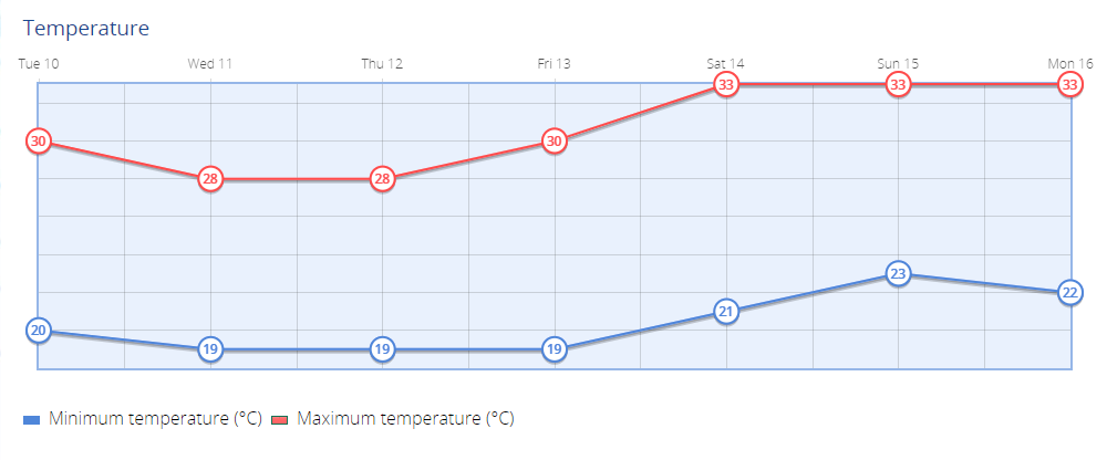
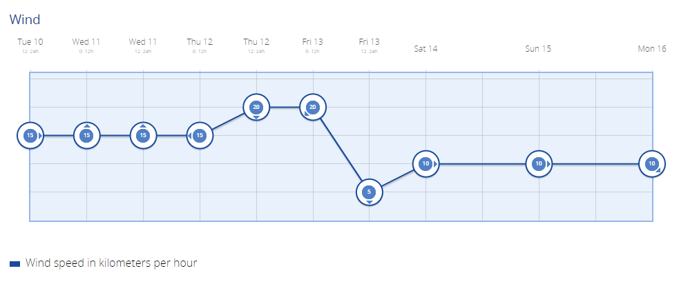
While temperatures forecasted range from lows of 19ºC at night to highs of 33ºC during the day, these figures are measured in the shade, meaning it will feel much hotter in direct sunlight. Strong trade winds will continue throughout the week, especially on the southeast and northwest slopes.
Tuesday:
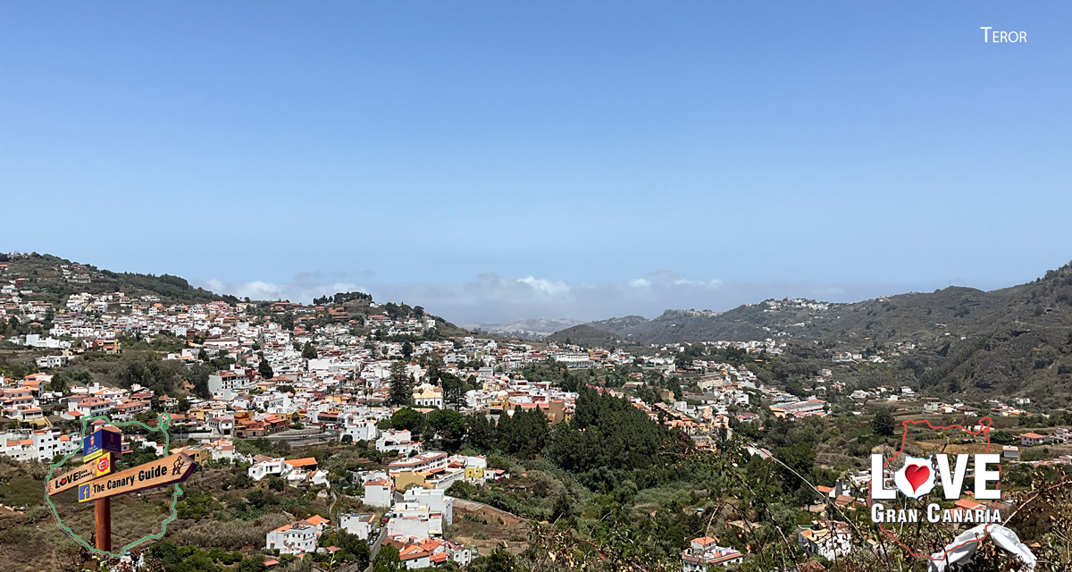
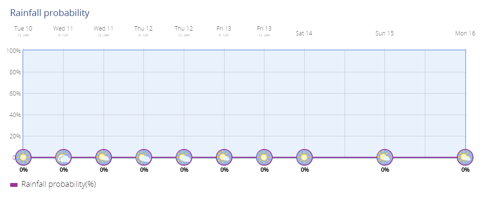
The northern areas of Gran Canaria below 900 to 1000 metres will see a mix of clouds, particularly in the early and late hours, while the rest of the island will experience partly cloudy skies with intervals of high clouds. Temperatures remain stable, with slight increases in minimums in the southern inland areas. Moderate trade winds will prevail across the island, but they will strengthen in the southeast and northwest, potentially leading to very strong gusts by the evening. Breezes are expected along the southwest coasts, while higher peaks will experience light winds shifting from west to northwest.
Temperatures: 22ºC – 26ºC
Wednesday:
In the northern areas up to 1200-1300 metres, cloudy skies will dominate, though there may be some afternoon clearings. There is a small chance of light, sporadic rain in the midlands by evening. The southern parts of Gran Canaria will remain partly cloudy with sunny intervals in the morning. Coastal temperatures will stay steady or slightly drop, while inland areas and the mountains will see a more noticeable dip, especially in maximum temperatures. Moderate trade winds will continue, growing stronger along the southeast and northwest slopes, with very strong gusts likely by day’s end. Breezes will persist along the southwest coasts.
Temperatures: 22ºC – 28ºC


Thursday:
The northern regions of Gran Canaria, particularly in the midlands, will again see predominantly cloudy skies, with a slight chance of light, occasional rain. Elsewhere on the island, the skies will be partly cloudy or mostly clear. Temperatures will see little change, though a slight rise in maximum temperatures is expected inland. Strong trade winds will persist, particularly along the southeast and northwest slopes, where very strong gusts could occur. Breezes will continue on the southwest coast.
Temperatures: 19ºC – 28ºC
Friday:
Cloudy intervals will return to the northern parts of Gran Canaria, while the rest of the island will enjoy mostly clear skies with some morning clouds. There is a chance of haze appearing at high altitudes over the eastern islands later in the day, but this should not significantly affect Gran Canaria. Temperatures will rise slightly, especially inland, with more noticeable increases in maximum temperatures. Strong trade winds will continue, with gusts remaining strong in the southeast and northwest. Breezes are expected along the southwest coasts.
Temperatures: 19ºC – 30ºC
Weekend Forecast:
Saturday and Sunday will see partly cloudy skies across much of Gran Canaria, with cloudy intervals more likely in the north. The trade winds will persist, but they will start to weaken slightly compared to previous days. Inland areas could see temperatures rise further, with maximums reaching up to 33ºC, especially in the southern and central parts of the island.
Temperatures: 21ºC – 33ºC (Saturday)
Temperatures: 23ºC – 33ºC (Sunday)
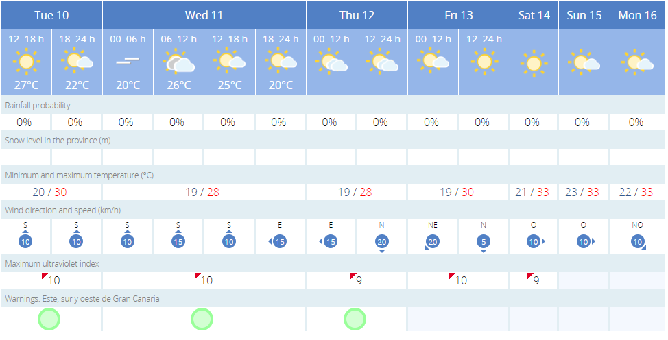
Looking Ahead to Next Week:
As we move into next week, the trade winds will gradually lose intensity, becoming light by midweek. Expect a mix of cloudy skies with medium and high clouds, and the possibility of occasional showers in the interior mountainous areas. Temperatures will remain mostly stable, with perhaps slight decreases towards midweek.
Temperatures: 22ºC – 33ºC


