The Spanish State Meteorological Agency (AEMET) in the Canary Islands this Saturday updated their warnings for rain on Sunday, September 25, on the islands of Gran Canaria, El Hierro and La Palma as tropical storm ‘Hermine’ passes to the south and west of the archipelago.
 The Red Advisory warning (the highest level) comes into force from 12:00 midday tomorrow for the east, south and west of Gran Canaria, where accumulated rainfall of 120 litres per square meter is expected over just a twelve hour period. Up to 180 litres per square metre have been predicted for the westernmost islands of La Palma and in El Hierro. In principle, if the alert is not extended, it will be in force until midnight tomorrow (23:59 hours).
Regional president of the Government of the Canary Islands, Ángel Víctor Torres, had already stressed on Friday that the Archipelago could receive “the most significant rains in a decade.”
From 3:00 p.m. this Saturday, a yellow advisory warning has been in force across the four islands of the western province of the Archipelago due to storms, with some predicting gusts of wind of up to 70 kilometres per hour, accumulated rainfall that could reach some 60mm over the next twelve hours.
The whole of the Canary Islands has been on high alert since midnight for rains, storms, wind and the potential for pluvial flooding.
 Floods and landslides
“The intensity and persistence of the rains may produce flash floods and landslides on slopes and areas with complex orography,” warns AEMET.

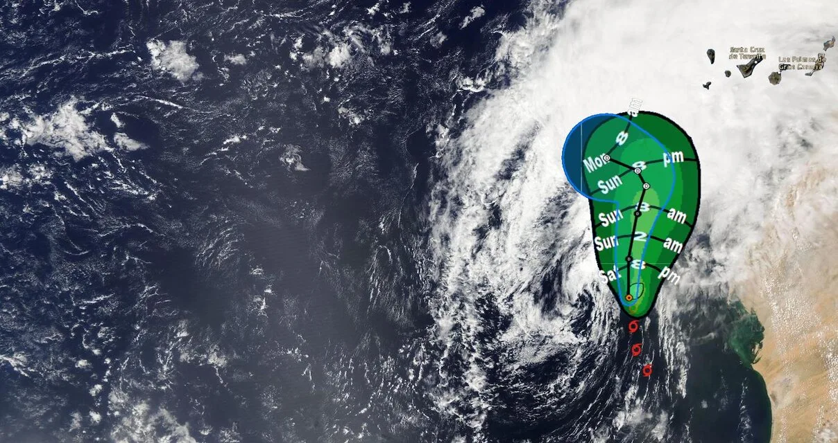
The tropical cyclone, Storm Hermine, has, at its core, sustained winds of 65 km/h (40mph), and a minimum pressure of 1002 hPa, and according to the US National Weather Service, National Oceanographic and Atmospheric Administration (NOAA) Hurricane Centre, based in Miami and responsible for the surveillance in the North Atlantic, the storm system is moving steadily north at about 13 kilometres per hour (8mph). As soon as those winds drop to 63km/h (39mph) or less then Hermine will cease to be classified as a storm. There is also a less than 5% probability of those winds reaching the archipelago according to the NOAA modelling.
Hermine is expected to continue moving north for the next several hours, turning northeast on Sunday afternoon and heading north west on Monday night as it comes into contact with drier air and weakens. Although the centre of the system will not reach the Archipelago, it will get close enough to produce widespread, intense and persistent rainfall, accompanied by stormy weather, through the course of this weekend and next Monday.
Throughout the entire episode an estimated 150-200 mm of water per square metre could accumulate, on the western islands, even above 250 mm in some points . Due to the intensity and persistence of rainfall, flash floods can occur in areas of ravines and torrents , as well as in low-lying areas. Likewise, the possibility of landslides on slopes and areas with complex orography is not ruled out.