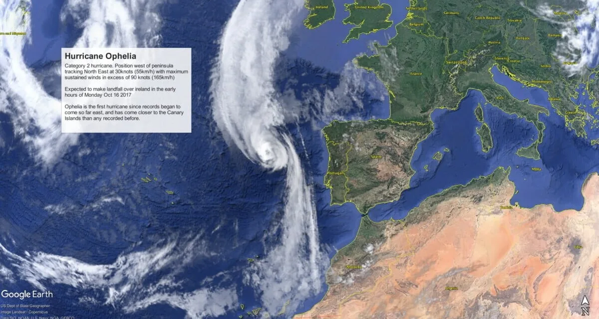
 ‘Ophelia’ has been named as the hurricane to come the closest ever to the Canary Islands since records began, say climatologists.
The warm African winds currently over the archipelago may well have acted as a buffer that helped ensure ‘Ophelia’ did not come any closer, protecting us from its tail end. Some suspect that Ophelia herself was the cause of that hot air being sucked up from the African interior.
The now level 2, Ophelia, will make her closest approach to the peninsular coasts of Spain and Portugal between Sunday afternoon and Monday morning, expected to generate winds of force 7 on the Galician coast, with waves of 4 to 5 meters high, as she continues to head up towards Ireland and the British Isles, by bazaar coincidence marking the exact 30 year anniversary of the Great Storm of 1987.

Those hot Saharan winds sucked up from the south east and from the equator continue to leave a dense cloud hanging over the archipelago, which is expected to clear over the next day or two.
The Spanish State Meteorological Agency (AEMET) has issued a statement following a report from the National Hurricane Center (NHC), based in Miami, which indicates the development of Hurricane Ophelia, active over the last last 3 days. The NHC reports that Hurricane Ophelia, currently a category 2 with maximum sustained winds of between 90 knots (165 km/h) and 110 knots (205 km/h), has picked up and is traveling northeastward at a speed of 30 knots (55 km/h).
 Yesterday afternoon and in the early hours of this morning Ophelia had been upgraded to a category 3, “the highest category hurricane that has travelled so far east in the Atlantic,” the statement said. She has now been downgraded again to a category 2.
By the start of Monday she is expected to be situated off the northwest tip of Spain near Finisterre.
From there it will continue advancing north east as a post-tropical cyclone with hurricane level maximum sustained winds. “In its passage through all these zones it will generate winds of force 8 to 12 and areas of mountainous sea”, AEMET predicts.

“Along the morning of Monday the wind is likely to subside but the bad sea will continue until the end of the day,” concludes the Aemet statement.
The Irish Met Office still has an active red alert and though winds are expected to decrease throughout Monday and Tuesday, Ophelia is still expected to be an active hurricane when she makes landfall on Monday.
The Great Storm of 1987 wrought havoc across the UK and analysis by meteorologists suggested that we could expect storms of that magnitude no more than once every 200 years… yet here we are just 30 years on…
Michael Fish, October 15 1987 before the Great Storm
30 years ago today!
An unforgettable moment from October 15 1987 when BBC forecaster Michael Fish made his famous gaffe regarding hurricanes, just before the mightiest storm since 1703 to hit the British Isles, felling 15million trees in one night, wreaking havoc across the united kingdom…
“Earlier on today, apparently, a woman rang the BBC and said she heard there was a hurricane on the way; well, if you’re watching, don’t worry, there isn’t, but having said that, actually, the weather will become very windy, but most of the strong winds, incidentally, will be down over Spain and across into France.”
Posted by The Canary News on Sunday, October 15, 2017