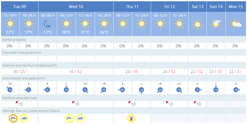
Gran Canaria is on the cusp of experiencing an exceptionally warm weather episode due to a warm and dry air mass of African origin that could reach 35°C in the shade. Anticipated to commence in the late hours of Tuesday the warm weather will persist for approximately a week, and temperatures forecasted to soar to unusually high levels for this time of the year, reaching up to 35°C at their peak, always measured in the shade, according to predictions from the State Meteorological Agency (AEMET). Temperatures in direct sunlight are expected to go much higher, particularly on the sunny south of the island.
|
----- Google provide a way for you to
|


The arrival of this warm air mass, coupled with an abundance of Saharan mineral dust, is expected to cause a progressive and significant increase in temperatures across the islands, with conditions resembling those of summer and exceptionally high for the current period.
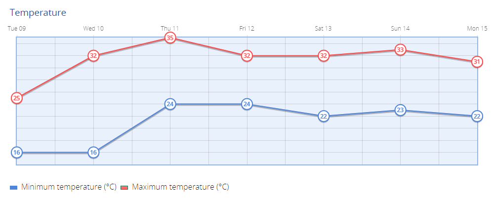
A notable increase in temperatures is expected to start on Wednesday, particularly on the eastern islands, including a moderate rise in the western islands. Temperature forecasts for Gran Canaria’s southern and western slopes, as well as interior regions of Lanzarote and Fuerteventura, are projected to be between 30°C and 32°C.
The warm weather conditions will on Thursday extend towards the western islands in the province of Santa Cruz de Tenerife. The combined effects of this warm air mass, strong winds, and sunshine will result in widespread maximum temperatures exceeding 30°C in most places. Specific areas such as the interior and south could experience temperatures reaching or surpassing 35°C in the shade.

The hot weather is expected to remain relatively unchanged until Sunday, with a significant decrease in temperatures forecasted by Monday, April 15. However, some isolated areas may still experience maximum temperatures around 30°C.
AEMET indicates that regions shielded by the cooler trade wind currents (generally coastal strips in the north) will not reach these most elevated maximum temperatures.
Recommendations: Given the forecasted calima event and the significant rise in temperatures, residents and visitors are advised to take necessary precautions to protect themselves from the heat and dust. This includes staying hydrated, seeking shade, and wearing sun protection.
Tuesday:
- Northern slopes: Cloudy skies during the early morning with a chance of weak and scattered rainfall, clearing up throughout the day.
- Elsewhere: Mostly clear or clear skies.
- Temperatures: Little change overall, except for a slight increase in maximum temperatures in the south.
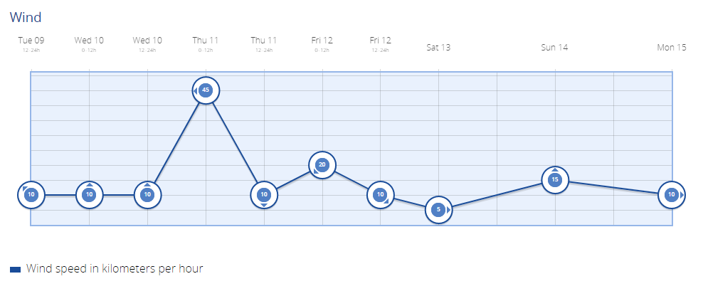
- Winds: Strong northeast winds with very strong intervals in areas typically exposed to the trade winds, with gusts exceeding 80 km/h. In the southeast slopes and summits, winds could surpass 90 km/h during the latter half of the day.
Wednesday:
- Clear skies predominating, with some intervals of low clouds on the northern coasts early in the morning and at the end of the day.
- Calima (dust) expected from midday, with the highest concentrations in the late hours, affecting the east and south slopes.
- Temperatures: Maximum temperatures will see a notable increase, except on the north coast where the increase will be moderate. Minimum temperatures unchanged or slightly increased in the south and west slopes, reaching 30 to 32 ºC in the southern half, possibly touching 34 ºC locally in midlands.
- Winds: Strong northeast winds with very strong intervals in areas typically exposed to the trade winds, gusting above 80 km/h during the early morning, then easing to moderate.
Thursday:
- Clear skies with probable calima affecting mainly the southern slopes.
- Temperatures: Maximum temperatures significantly rising in the western islands and moderately in the eastern islands. Minimum temperatures will moderately to notably rise in general, reaching widespread 30 ºC, with possible peaks above 34 ºC in specified areas of several islands.
- Winds: Moderate northeast winds with strong intervals in typical acceleration zones of the trade winds at low levels. In the midlands and interior zones of Lanzarote and Fuerteventura, eastern component with strong intervals in the south and north slopes of the larger islands during the first half of the day, shifting to northeast by the end of the day. Moderate easterly winds in the summits, calming and shifting to northeast late in the day in the eastern islands.
Friday and into the weekend:
- Clear skies with the calima likely subsiding.
- Temperatures: Decreasing in Lanzarote and Fuerteventura, as well as in the maximum temperatures of La Gomera and the lower areas of the central islands. Little change or slight increase elsewhere, with 30 ºC expected across much of the archipelago, potentially exceeding 35 ºC in certain areas.
- Winds: Moderate northeast winds with strong intervals in typical acceleration zones at low levels. In the midlands and interior of Lanzarote and Fuerteventura, moderate northeast winds easing to light by the end of the day. Light to moderate variable winds in the summits of the larger islands.
General Outlook:
- Temperatures will increase in the eastern islands and remain unchanged elsewhere, maintaining very high values for the season across the archipelago.
- A likely presence of weak trade winds across the Canary Islands, with no significant changes expected. Temperatures will stay above normal for the season, with weak trade winds and breezes on the more mountainous islands.