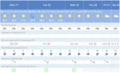
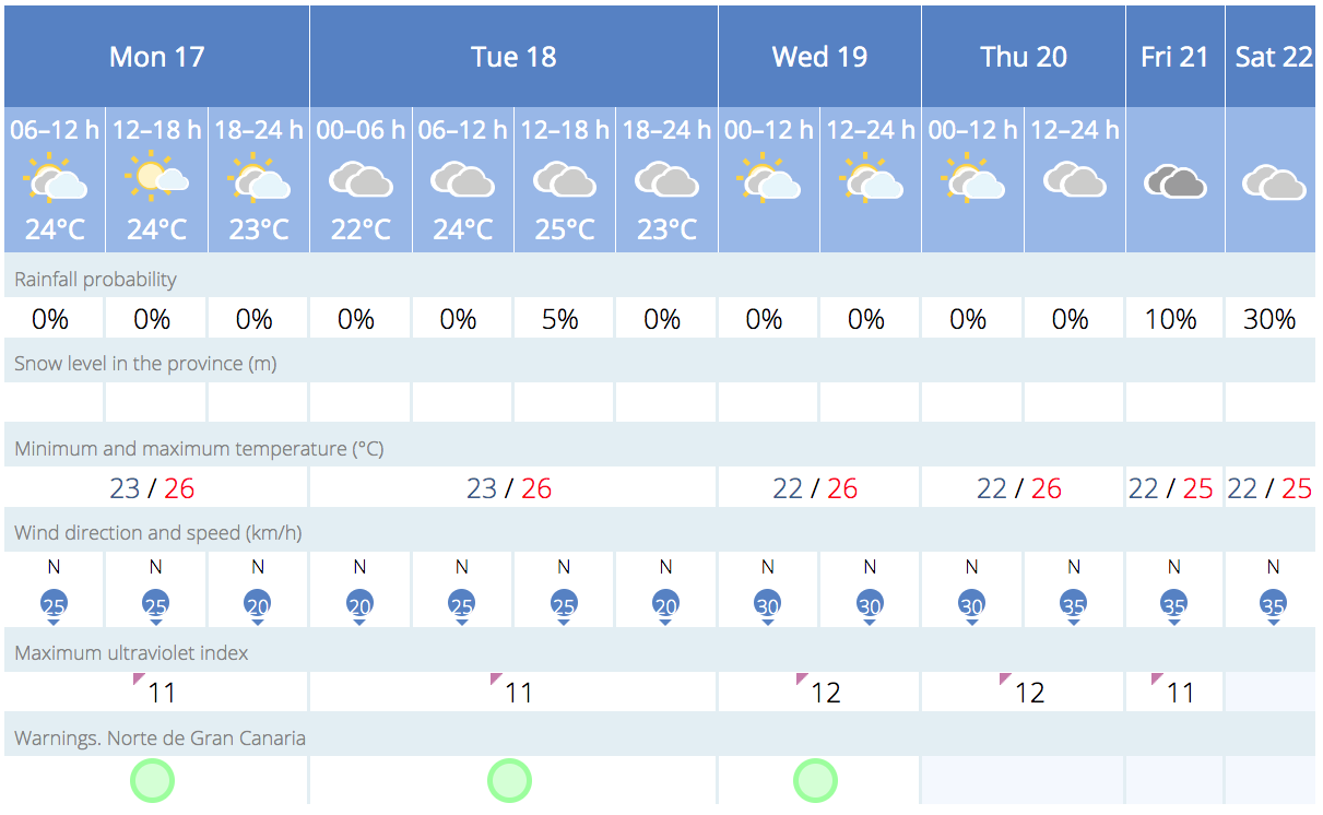
Cloudy skies will prevail in the northern mountains on Monday, with a low probability of scattered and occasional light rain in the midlands during the morning, according to AEMET (Spanish State Meteorological Agency).
Elsewhere, the weather should be mostly clear, with some intervals of cloud to the north and west.
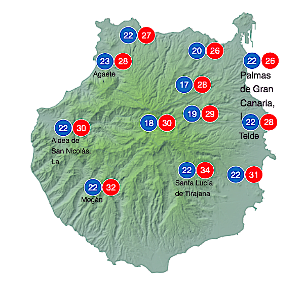
Temperatures will remain stable or drop slightly in the midland areas of the south and west.
|
----- Google provide a way for you to
|

 Winds will blow from the northeast, with moments of higher intensity on the southeastern and northwestern slopes, with breezes on the southwest coast. At the summits, the wind will be light and variable, with a tendency to blow from the east in the afternoon.

Out at sea, a prevailing northerly or northeasterly wind is expected, of around force of 5 or 6, increasing to force 7 offshore to the west and on southeastern coasts until the early hours of the morning. Strong swell, is expected to locally become rough offshore at times in those same areas. Along the north coasts, the wind will be from the north or northeast, at force of 3 or 4, with slight to moderate waves. Variable wind conditions, accompanied by breezes, are expected along the south and southwest coasts, and the sea could be choppy with slight to moderate waves. To the north waves ranging from 1 to 2 meters high.
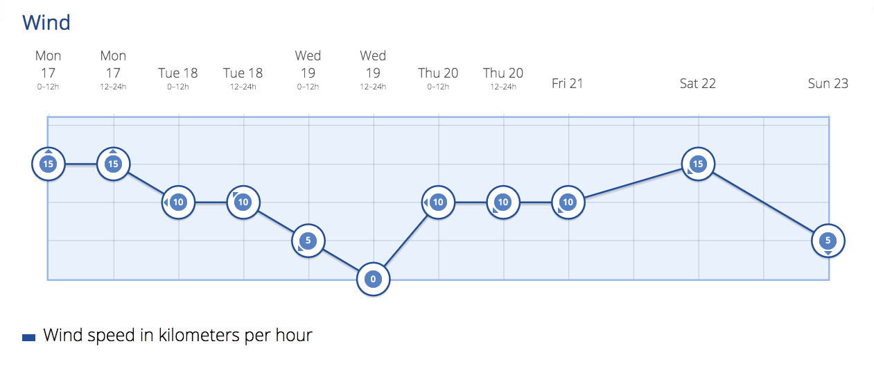
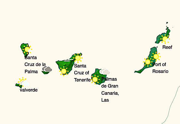
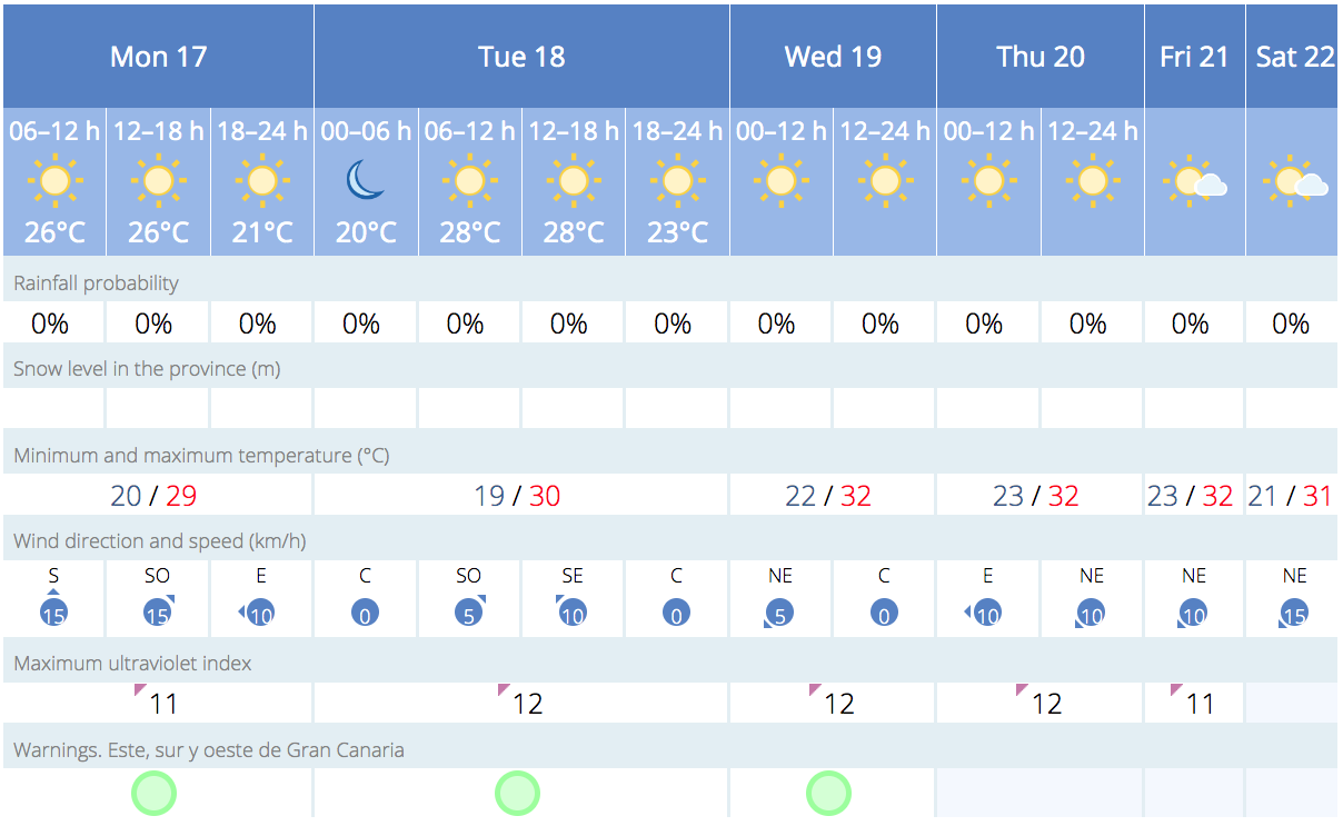
 Intervals of cloud are expected from the north to start the week, especially in the earlier and later hours of the day. Clear skies should prevail across the rest of the island remaining relatively unchanged, with slight decreases in minimum temperatures on the southern slopes and a slight increase in maximum temperatures on the north slopes. The winds will be from the northeast, occasionally strong on the southeast and northwest slopes, and breezy on the southwest coast. On the mountain peaks, the wind will be light and variable, predominantly from the east.
On Tuesday, there will be intervals of cloud across the north. Elsewhere, the skies will be partly cloudy or clear. Towards the late hours, there may be a light Calima haze affecting higher altitudes. Minimum night time temperatures will remain relatively unchanged. Maximum temperatures during the day with little variation along the coasts and a slight increase in inland areas, particularly noticeable in high-altitude zones. The wind will be from the northeast, occasionally strong on the southeast and northwest coasts, with breezes along the southwest coast. On the mountain peaks, the winds will be light and variable, predominantly from the south.
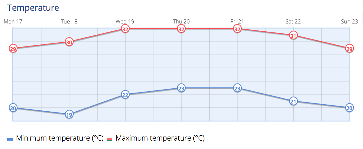
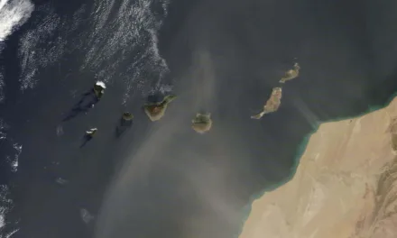
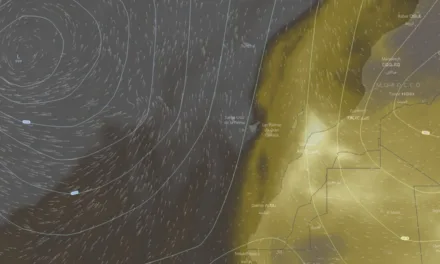
By midweek, the skies will be partly cloudy with intervals of clouds in low-lying areas of the north to start Wednesday off. There will be a light Calima haze affecting higher altitudes, with more intensity on the easternmost islands of the archipelago. Temperatures should see a slight increase, particularly noticeable inland. The winds will be from the northeast, occasionally strong on the southeast and northwest coasts, with breezes along the southwest coasts. On the mountain peaks, the wind will be light and variable, tending to shift to a northerly direction in the afternoon.
On Thursday, intervals of clouds, with cloudy skies prevailing towards the late hours, on the north of the island. Elsewhere skies should be mostly clear or clear. There will be a light Calima haze affecting higher ground, gradually dissipating. Minimum temperatures should remain relatively unchanged. Maximum temperatures may experience a slight decrease. The winds will be from the northeast, gradually increasing in the afternoon, with intervals of strong winds possible on the southeast and northwest slopes. On the summits, there will be a light to moderate northerly winds.
As the week comes to a close in the Canary Islands, a moderate to strong trade wind will continue to blow. The skies will see intervals of low cloud to the north of the islands, with the possibility of some scattered and light showers, while the rest of the archipelago will have mostly clear skies. Temperatures continue decreasing.
-
- Mogán & South West
-
- Las Palmas de Gran Canaria

|