The Ministry of Health of the Canary Islands Government has issued an orange alert as part of the Preventive Action Plan for the Effects of Excess Temperatures on Health. This alert is in effect for Tuesday and Wednesday in the areas of San Bartolomé de Tirajana and Santa Lucía de Tirajana.
|
----- Google provide a way for you to
|


According to the State Meteorological Agency (AEMET), the weather forecast for the week indicates cloudy intervals in the north and clear skies for the rest of the islands. In Gran Canaria, the capital can expect the presence of the “Panzo Del Burro” or “donkey belly” cloud formation, while the remaining parts of the island will experience mostly clear skies or a few clouds. This weather pattern is expected to repeat in Lanzarote and Fuerteventura.
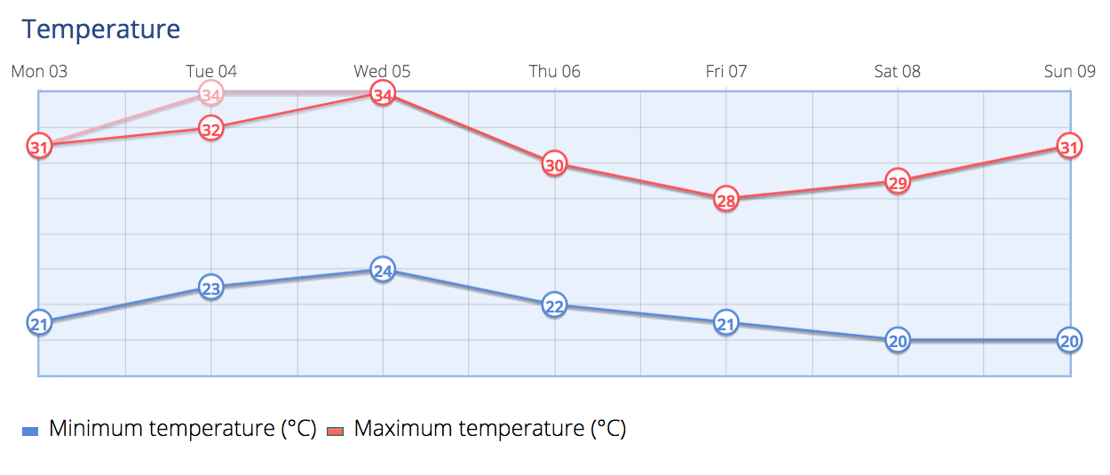
Minimum temperatures will remain relatively stable, with slight decreases in the interior areas of the mountainous islands. Maximum temperatures will remain consistent, with minor increases in higher elevations and slight drops in the central areas of southern Gran Canaria. The prevailing wind will be from the northeast, with strong gusts on the southeast and northwest slopes. Breezes will prevail along the southwest coasts of the mountainous islands. In the summit areas, the wind will be variable, except for the high peaks of Teide, where it will be moderately to strongly blowing from the southwest during the latter part of the day.
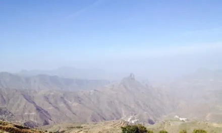
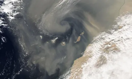
The presence of calima, a weather phenomenon characterised by dust and sand in the air, is expected towards the middle of the week. There is a possibility that temperatures may exceed 32ºC in inland areas of Fuerteventura and in the midlands facing south of Gran Canaria and Tenerife. Breezes will blow on the southwest-facing coasts.
Trade winds will be present, with strong gusts in the channels between the islands. Temperatures will experience little change or slight decreases on Friday, followed by an increase starting from Saturday.
Gran Canaria Weather Forecast for the Week Ahead:
On Tuesday, the north-facing coasts will experience cloudy intervals during the day, becoming cloudy in the early and late hours with clear skies in between. In other areas, skies will be mostly clear or with occasional intervals of high cloudiness. There is a low probability of haze at higher altitudes, primarily affecting the southern slope. Temperatures will slightly rise, with more noticeable changes in the interior regions. It may exceed 32ºC in the midlands facing south, and an orange advisory notice may be in place in the south and south-east. The wind will be from the northeast, with some strong gusts in the extreme northwest and southeast slopes. Breezes will prevail along the southwest coasts. In the summit areas, there will be light winds predominantly from the west.
Forecasted Minimum and Maximum Temperatures (°C):
Las Palmas de Gran Canaria: 22º – 26ºC
Maspalomas / Puerto Rico de Gran Canaria: 28º – 32ºC

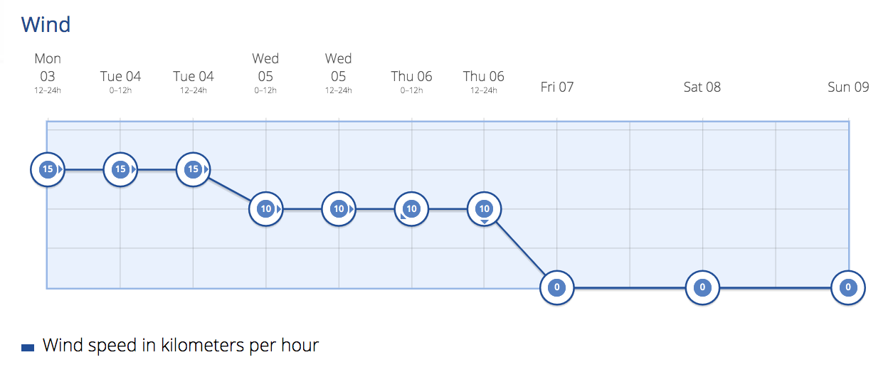
Wednesday will be slightly cloudy or clear, with some cloudy intervals in the morning and at dusk along the north coasts. There is a low probability of haze at higher altitudes, primarily affecting the southern slope. Temperatures will rise, with the orange advisory notice staying in place for most of the day time, particularly in San Bartolomé de Tirajana and Santa Lucia. It may exceed 32ºC, in the shade, in the midlands facing south. The wind will be moderate from the northeast, with some strong gusts in the extreme northwest and southeast slopes. In the summit areas, there will be light winds predominantly from the west.
By Thursday, the northern part of the island will see a little more cloudiness, with clearings opening up during the central hours. In other areas, skies will be mostly clear. Temperatures will notably drop in the middle and high elevations, with slight decreases along the coasts. The wind will be moderate from the north, with strong gusts on the northwest and southeast slopes.
Moving into the weekend, Friday will continue with cloudy conditions in the north, with a chance of light rain, and minimal cloud cover elsewhere. Temperatures will see few changes, perhaps a slight decrease, particularly in the maximum temperatures of mid-altitude and higher areas. The wind will be moderate from the north, with strong gusts on the northwest and southeast slopes. Saturday and Sunday are expected to have similar conditions, although winds may intensify as the next week approaches.
 The Ministry of Health of the Government of the Canary Islands, through the General Directorate of Public Health, issues notice of the PEFMA Preventive Action Plan for the Effects of Excess Temperatures on Health, for the island of Gran Canaria, to reduce adverse health effects among the population, particularly associated with excessive temperatures, they are coordinating Canary Islands institutions, to activate emergency health care systems, in coordination with the Ministry of Health and the State Meteorological Agency (AEMET).
GRAN CANARIA – Level 2 Orange advisory notice
Orange advisory notice on July 4 and 5 for San Bartolomé de Tirajana and Santa Lucía de Tirajana.
Temperature thresholds and risk levels
The temperature thresholds established in 2023 are 33 degrees Celsius for the province of Las Palmas de Gran Canaria, and 34 degrees Celsius for the province of Santa Cruz de Tenerife.
The criteria for assigning the levels of risk to health for situations of excess temperature, determined by the Ministry of Health, is based on a decision algorithm. Based on this algorithm, based on the expected maximum temperatures, the established threshold, the number of days of persistence, which is specified in a minimum of three, and the risk factors of each territory, four risk levels are determined:
- ◦ Level 0 (green), of absence of risk.
- ◦ Level 1 (yellow), low risk.
- ◦ Level 2 (orange), medium risk.
- ◦ Level 3 (red), high risk.
Recommendations
Vulnerability to high temperatures includes personal risk factors, such as being over 65 years of age, infants, pregnant women, etc., environmental, local and occupational risk factors, among others. The recommendations addressed to the vulnerable population especially are:
- Stay as long as possible in cool, shaded or air-conditioned places, and refresh yourself whenever you need to.
- Reduce physical activity and avoid practicing outdoor sports in the central hours of the day.
- Drink water or liquids frequently, even if you don’t feel thirsty and regardless of the physical activity you do.
- Avoid drinks with caffeine, alcohol or very sugary drinks, as they can promote dehydration.
- Pay special attention to: babies, minors, pregnant or lactating women, as well as the elderly or people with diseases that can be aggravated by heat (such as heart disease, kidney disease, diabetes, hypertension, obesity, cancer, pathologies that impede mobility, dementia and other mental illnesses, as well as drug or alcohol abuse). Although anyone can suffer from a heat related problem.
- Wear light, loose clothing that allows perspiration.
- Do not leave anyone in a parked and closed vehicle (especially people who are minors, the elderly or those with chronic illnesses).
- Consult a health professional for symptoms that last more than an hour and that may be related to high temperatures.
- Eat light meals that help replace the salts lost through sweat (salads, fruits, vegetables, juices, etc.).
- Keep medicines in a cool place; heat can alter its composition and its effects.
Other preventive plans in the Canary Islands
Faced with a situation of maximum temperatures, the Government of the Canary Islands can activate this Plan for the Prevention of Excess Temperatures in the Health of People, with health risk warnings, as well as others such as the Specific Plan for Civil Protection and Emergency Care for Risks due to Adverse Meteorological Phenomena (PEFMA), by declaring an alert due to a situation of risk to the population, goods and the environment.