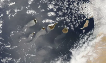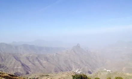
After the hottest temperature in Spain, ever in the month of March, was recorded on the west of Gran Canaria last Thursday, the Canary Islands are experiencing a sudden flip in the weather, with temperatures dropping and cloudy skies to the north of the most mountainous islands.
Northwesterly winds are expected, with strong intervals on southeast and northwest slopes. Very strong gusts are likely, particularly in the aforementioned areas and on the easternmost islands.
|
----- Google provide a way for you to
|


The State Meteorological Agency (AEMET) has issued a special prediction for Easter, forecasting overcast skies and rain to the north on Tuesday, April 4.
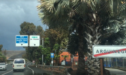
Of Course the very best places to be on Gran Canaria will be the south, in the lee of the island, where despite the strong winds, clouds and possible rain from the north the maximum sunshine hours and blue skies are expected. Some in Maspalomas and Puerto Rico de Gran Canaria may not even notice a change in the weather

The winds will blow from the north with some real intensity, gusting to 70km/h and more, with temperatures experiencing a sharp drop.
Clouds and rain will continue on the north on Wednesday, April 5, along with strong north winds and very strong gusts.
The skies are expected to clear up some on Thursday, April 6, with decreasing probability of rainfall. Cloudy intervals, a light northerly wind, and stable temperatures are expected on Friday, April 8 and Saturday, April 9, but increasing instability and rainfall across the archipelago is possible on Sunday, April 10.

AEMET has activated a yellow advisory warning for maximum gusts and coastal phenomena across the southern parts of the archipelago, with gusts of up to 70 km/h and stronger.
The weather forecast for Tuesday, April 4, predicts cloudy skies with probable rains, generally weak, and strong gusts of wind as well as strong swells out to sea, and northwest swell with waves of 2 to 3 metres.
Las Palmas de Gran Canaria is expecting temperatures in the shade ranging from 18º to 21º C.
Wednesday will see cloudy skies to the north with probable weak to moderate rainfall. The rest of the island will have cloudy intervals, with light rain during the early morning and late hours. Clearings are expected during the afternoon. Maximum temperatures will rise slightly on the northern half of the island while remaining with few changes elsewhere. The north winds will be strong with gusts above 70 km/h on the northwest and southeast slopes, as well as on the summits. It should subside during the second half of the day.

Thursday will be cloudy on the northern coasts with a low probability of weak and occasional rain during the early hours of the day. Expect cloudy intervals during the rest of the day, with skies clearing during the central hours. Elsewhere, there will be some cloudiness. Maximum temperatures will rise slightly, more pronounced inland. The wind will be moderate with strong intervals from a north component, more intense on the summits and on the northwest and southeast slopes of the mountainous islands. Expect it to decrease from noon, except on the peaks of Gran Canaria.
Friday should be cloudy too on the northern coasts, where light and occasional rain is possible during the early morning. Elsewhere, there will be a little cloudiness or clear skies. There may even be some light Calima haze at high levels. Temperatures will be maintained. The north component to the wind will be more intense on the northwest and southeast slopes, with light winds of variable direction at the summits.
The weekend in the Canary Islands will be slightly cloudy or see cloudy intervals, with a possibility of weak showers associated with the diurnal evolution of cloudiness.

AEMET Special Notice for Easter 2023
 Tuesday 4th to Thursday 6th: Stable and dry weather is likely to prevail in the Peninsula and Balearic Islands due to the presence of a high-pressure system, although some weak precipitation in the northeastern region cannot be ruled out. In contrast, the tendency in the Canary Islands is towards instability, with the possibility of a low-pressure system forming on Tuesday north of the archipelago, which could lead to widespread precipitation. Temperatures, both maximum and minimum, are gradually rising in the Peninsula and Balearic Islands, with frost in the northern half tending to diminish. In the Canary Islands, temperatures are tending to drop. Winds are expected to weaken, except in the Strait of Gibraltar, where strong easterly winds with very strong gusts are expected.
Friday 7th to Saturday 8th: There is increased uncertainty in the forecast for these days due to the low-pressure system approaching the south of the Peninsula, but progressive increase in instability is likely. Depending on its final location, precipitation is possible in various areas of the Peninsula, more likely in the southern and northwestern quadrants, with the possibility of thunderstorms in inland areas in the afternoon. Temperatures are likely to decrease, although with considerable uncertainty. Winds are expected to blow from the east. In contrast, the tendency in the Canary Islands is towards progressive stabilization, although precipitation is still possible in the western islands, with temperatures tending to rise.