The Canary Islands are yet again expecting to spend the next few days in short sleeves, flip-flips and shorts, due to warning advisories from the Spanish State Meteorological Agency (AEMET), among others, due to yet another wave of incoming high temperatures. This latest heatwave, though for many a little less oppressive than the back to back swelters we experienced throughout July, is expected to persist throughout this week, at least until Thursday.
Gran Canaria will once again be the island most affected by high temperatures, with orange advisory warnings issued for this Tuesday and Wednesday, and maximum daytime temperatures, in the shade, of up to 40ºC, followed by yellow advisories on Thursday, when maximum daytime temperatures of up to 34ºC are expected, as ever it will be hotter in direct sunlight.

Inland Gran Canaria, the midlands and south facing summit slopes are expected to see the highest temperatures over the next few days, 40ºC expected in the Tirajana valley likely to affect mountain communities such as Santa Lucia and Tunte, and daytime temperatures in the shade expected to touch 37-38ºC across the southern half of the island. At the summits, particularly inland areas facing west, south and southeast, such as the Tejeda basin, high temperatures are also expected. Temperatures will be a little more bearable on the coasts, with light breezes helping to keep things a little cooler.

Significantly, just like the last two heatwaves of recent weeks, AEMET point to night time minimum temperatures again remaining remarkably high, with Calima haze, caused by dust from the Sahara, also continuing throughout the archipelago, mainly on the easternmost islands.

Health Risk Warnings
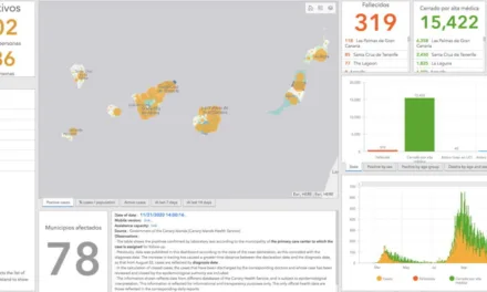
The Canary Islands Ministry of Health, through the General Directorate of Public Health, have announced the extension of the health risk warnings, due to high temperatures, expected in several municipalities in the archipelago. All on Gran Canaria, at high risk until Sunday, August 7. Yellow notices have also been issued for low risk on Tuesday and Wednesday elsewhere, mostly on Tenerife.
Red Warning (high risk)
- Agüimes
- Ingenuity
- Mogán
- San Bartolomé de Tirajana
- Santa Lucia de Tirajana
- La Aldea de San Nicolas
- Artenara
- Tejeda
 Yellow Notice (low risk)
- Santa Brígida
- Valsequillo
- Vega de San Mateo
- Arona
- Fasnia
- Granadilla de Abona
- Güímar
- San Miguel de Abona
- Candelaria
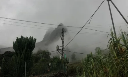
Cloud cover
Early morning cloud cover this Tuesday appears to have slowed the advance of the heatwave, but as we enter the afternoon, so the predictions of high temperatures are expected to hold, with members of the public being advised to take precautions, staying out of direct sunlight and ensuring that they keep hydrated, paying special attention to the elderly, the young and to pets, all of whom may be more susceptible to extreme heat.

Coastal phenomena
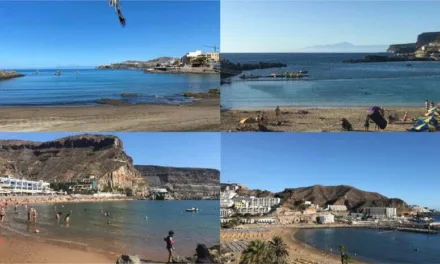
There are also warnings in place due to rough seas; specifically, to the east, south and west of Gran Canaria and Tenerife, as well as La Gomera and El Hierro, with waves of up to 7 meters expected offshore . The warning notice will end on Thursday, and so anyone going to sea or spending time on the beaches are being urged to pay attention to any warning signals and to keep an eye on anyone going into the water.

Playa del Inglés Beach: