The Calima affecting the archipelago for the last day or so continues this Wednesday, but is expected to begin to dissipate visibly from Thursday, which in turn will deactivate the yellow warning for fine North African dust suspended in the air, along with the yellow warning for strong winds, from about 5pm on Wednesday afternoon.
Two days of calm clear weather are expected to act as a prelude to a radical change in the forecast, according to the Spanish State Meteorological Agency AEMET, starting from the early hours of this Sunday morning, with the arrival of rains that could well be accompanied by storms, if the currently expected formation of a low pressure system between the Canary Islands and the Iberian peninsula continues as forecast by AEMET on their longer-range forecasts.
|
----- Google provide a way for you to
|
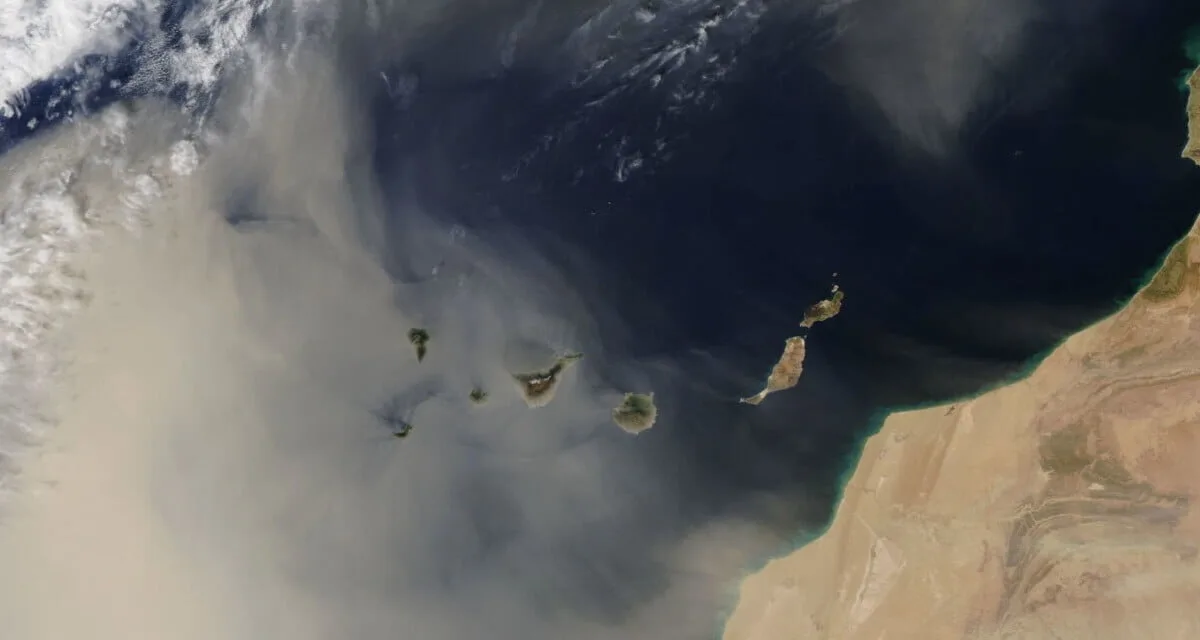
On Tuesday morning, the Calima unexpectedly caused the cancellation of six flights between La Palma and Tenerife, and another two from Gran Canaria, as well as the cancellation of the first morning flights from the island of El Hierro, with the suspended dust on Monday having affected Lanzarote and Fuerteventura as expected during the afternoon and evening, yesterday the dust cloud extended to the two westernmost islands, which had not been forecast, passing across the south of the central islands on its way towards the Atlantic.
Air pollution measurements in some parts of the western province of Santa Cruz de Tenerife rose up to 900 micrograms of PM10 particles per cubic metre of air, and reduced visibility down to just 1,500 meters, although in most places visibility remained higher than the 3,000-4,500 meters.
In the other capital of Las Palmas de Gran Canaria, a PM10 particle pollution peak at 3am on Tuesday reached 868 micrograms per cubic metre of air, which reduced as the hours passed, so that by five o’clock in the afternoon, a more restrained, but equally harmful, 191 micrograms per cubic metre of air was measured.

The World Health Organization establish a recommended safe environmental limit of just 40 micrograms per cubic metre of air for daily exposure to PM10 particles, which has been in force since 2005, is, and so the Canary Islands Government Ministry of Health have repeated warnings for citizens to avoid going outside during such strong Calima’s so as not to aggravate conditions or symptoms related to any respiratory diseases, among which they cite asthma and COPD or chronic obstructive disease, which can be made more serious by the airborne dust, which in turn risks increasing admissions to emergency services and even hospital admissions in the worst cases.
The Government recommend keeping doors and windows closed; cleaning dusty surfaces using damp cloths; staying in humid environments and keeping hydrated; as well as avoiding physical exercises outside; and, in case of worsening symptoms, a call to the main 112 emergency services helpline will ensure you receive advice or help should you need it.
The Canary Islands Government is recommending that these precautions should continue to be taken throughout Wednesday, at least until this afternoon, at which time the yellow warnings are expected to be officially deactivated for Calima and strong winds.
The forecast points to visibility once again falling below 3,000 metres, and even with occasional peaks of down to about 1,500 meters, with temperatures similar to yesterday or slightly decreasing, and winds also decreasing in intensity as that the day goes on, but for the first half of the day there will still be intervals of strong wind, particularly on the west and north west of Gran Canaria.
On Tuesday gusts of wind reached speeds of up to 90 kilometers per hour at the highest part of Tenerife, while sustained winds of about 50 kilometers per hour were recorded on Gran Canaria.
The Gran Canaria municipalities of La Aldea de San Nicolás and in Mogán, temperatures in the shade were around 24ºC and even higher in Puerto de Mogan.
With no other active warnings forecast on Thursday by the Spanish State Meteorology Agency, the suspended dust is expected to continue blanketing the skies of the islands, but already beginning to lessen by the end of Wednesday.
By Friday, the retreating dust haze should leave clear skies, and light winds, still from the east, but changing to blow from the west by the end of the day.
Saturday, in principle, should be a day of transition while we monitor the potential formation of a low pressure system that by early Sunday morning could reach the Canary Archipelago with heavy rainfall accompanied by storms, on both the north slopes and those facing the west.