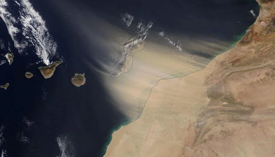
The Spanish State Meteorological Agency (AEMET) has forecast Calima for this Carnival Monday, February 15, with Saharan winds from the afternoon on the eastern isles of Lanzarote, Fuerteventura, La Graciosa, and by the end of the day the south and east of Gran Canaria.
The weather phenomenon is not expected to produce significant reductions in visibility, however airborne dust will bring an increase in temperatures from the this Sunday afternoon remaining moderately high on Monday and falling again by Tuesday or Wednesday.
|
----- Google provide a way for you to
|
AEMET has reported that there will be a southeasterly wind throughout the day and that it could be more intense on Lanzarote, La Graciosa and the north of Fuerteventura, with gusts of between 65-70 kilometres per hour possible, with similar arriving by the end of the day on Fuerteventura and Gran Canaria.
 Saturday:
Cloudy skies to the north and east, with possible light rains. Elsewhere, a touch of cloudy or clear. Temperatures staying much as they have been, night time lows of 13ºC and day time highs of 23ºC in the shade. Moderate northeasterly winds, with some strong intervals on the southeast and northwest slopes. Breezes predominantly on the northeast and southwest coasts.

Sunday:
A touch of cloud or clear, with some cloudier intervals to the north during the morning. Minimum temperatures remaining around 13ºC and maximums slightly higher reaching 24ºC gaining moderately at the summits. Moderate northeast winds, more intense on southeastern and northwestern slopes. Inland and at the peaks, during the afternoon winds of around 10km/h from the south becoming predominantly easterly. Breezes along the northeast and southwest coasts.

Monday:
The week starts clear this Carnival Monday, with a little cloud. Calima arriving to the islands of the eastern province, Las Palmas, during the second half of the day. Temperatures continuing to rise moderately, lows of 16º and highs of 26º in the shade. Moderate east winds of 35km/h on Gran Canaria, and higher in some places on the north and east of the island, with strong intervals, during the second half of the day inland and in higher altitude areas, increasing on islands to the east, with gusts above 60 km/h possible. Calima likely to leave a layer of Saharan dust, this Carnival Monday, on the eastern side of the province.
Tuesday:
Clear, with some intervals of high cloud. Calima, across the eastern province from the early hours of the morning and spreading during the day from east to west, tending to decrease by the end of the day. Temperatures starting to drop, with lows of 16º and highs of 23ºC in the shade. Moderate easterly winds with strong intervals, except inland, where winds will be strong and from the southeast with occasional strong gusts in the early morning and later in the day.

Wednesday:
High cloud. Slight Calima haze is not ruled out, which will tend to subside during the day from east to west. Temperatures in slight to moderate decline, lows of 13ºC and highs of 23ºC in the shade. Moderate southeast winds of 15-20km/h with strong intervals inland during the first half of the day, tending to decrease and turn weaker to blow from the northeast from noon. At the summits moderate to variable southeast winds.
Thursday:
It is probable that a new Atlantic front will head towards the mainland as we move towards the end of the week, bringing rain to the peninsula. Temperatures starting to increase once more across the Islands, with lows of 13ºC and highs of 24ºC in the shade. Winds from the east, with the southerly component.

Mogán 6 day forecast

Playa del Inglés beach this weekend