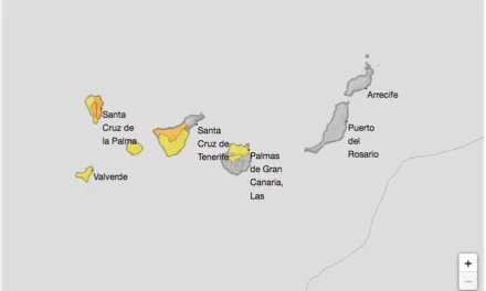
An Autumnal few days ahead, with warnings in force this week across The Canary Islands for very strong gusts of wind and some rain expected with occasional showers, even the potential for storm weather. Gran Canaria and the eastern province are likely to escape the worst of the wet weather, however meteorologists are predicting a 100% probability of rain, starting from Tuesday.
 The week has begun with bright blue skies across Gran Canaria and calm flat seas, temperatures ranging from 19º – 27ºC in the shade, however the tail of atlantic storm Bárbara is expected to travel across the islands as the week moves on. Tuesday will start a little cloudy growing increasingly grey from west to east. Generally weak rains will start out on the western isle of La Palma and gradually move towards the east. Occasionally heavy showers and storms are likely to start from La Palma, moving to La Gomera, and on to the north and west of Tenerife by noon. Minimum temperatures in general rising, as will maximum temperatures, except at peaks and summits where a decline is expected. Moderate to strong southwesterly winds, with some very strong gusts, gradually turning and tapering off to weak to moderate northwesterly by the end of the day.

Wednesday looks set to begin with cloudy skies and generally weak rain, although heavier showers are possible on the more mountainous islands, especially on eastern slopes during the afternoon. Temeratures will decrease, the fall in maximum temperatures more pronounced. Loose to moderate northwesterly winds, with strong intervals inland and in higher altitude areas during the early hours.


Thursday will start with cloudy intervals and weak rains in general, with heavier showers possible on the more mountainous islands, mainly on the north and east facing slopes. Temperatures may slightly decrease. Moderate winds from the north. So although a week of wind and some rain, nothing really to worry about as clear blue skies return in time for the weekend.