It’s the Constitution Day Bridge Weekend, with bank holidays on Wednesday and Friday, meaning that many will have also taken off Thursday to make a five day break to start the seasonal shopping season. Temperatures into the weekend looking to remain at between 18º and 24ºC in the shade. With the sun rising around 07:40 and setting again just after 6pm. The waning crescent moon transitions to a new moon on December 12 so plenty of stars visible on clear nights as the gradually less visible lunar surface orbits closer to the sun from our perspective.
|
----- Google provide a way for you to
|

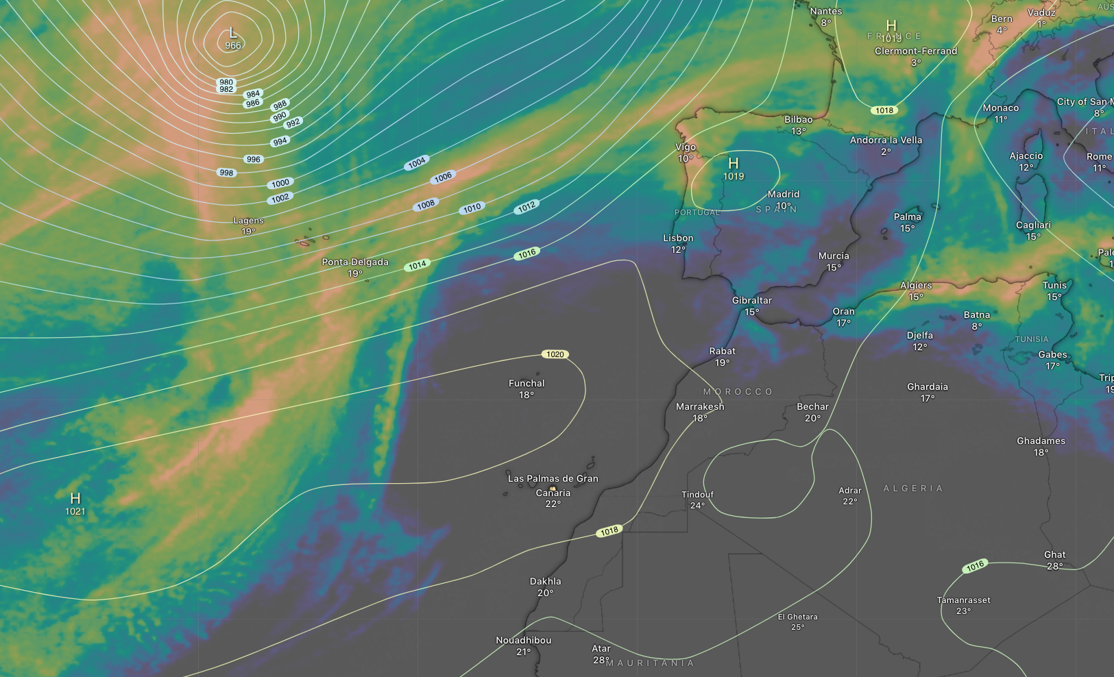
Atlantic Accumulated Rain forecast (by Windy)
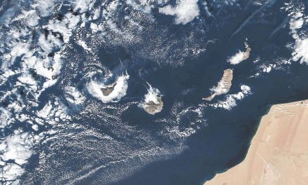
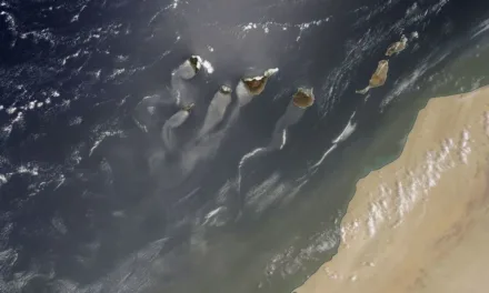
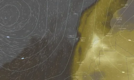
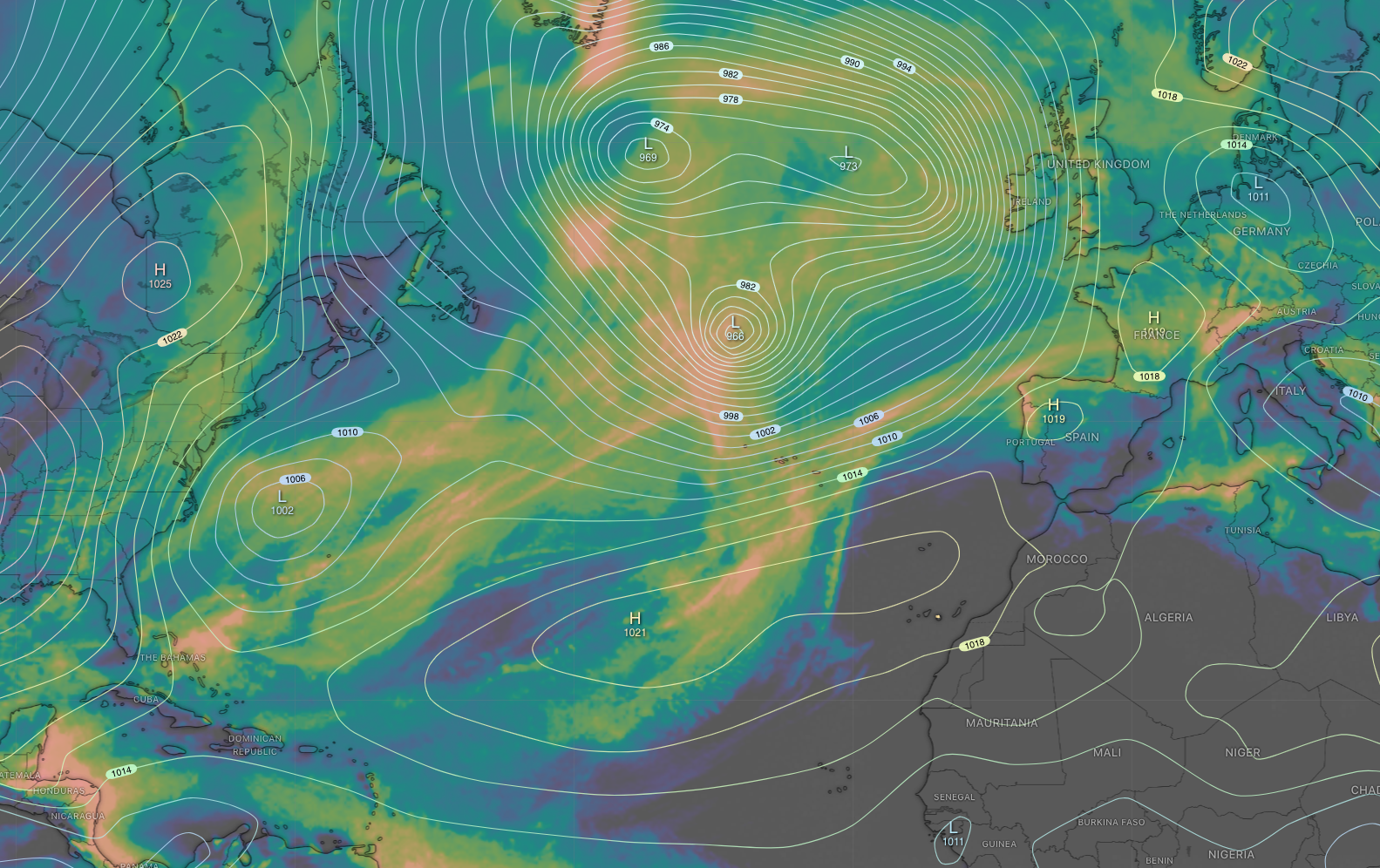
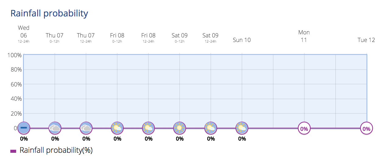
The mild Gran Canaria winter is fast approaching, and the island is gearing up to embrace it fully. Last week’s Atlantic squalls dampened various parts of the archipelago, and while the December holidays have been forecast to bring some light drizzle, it’s a renewed chill to the air that will mark more typically autumnal days for this time of year. However as you can see from the Accumulated Rain forecast (by Windy) a ridge of high pressure across north Africa appears to be keeping the Atlantic rainstorms at bay for the foreseeable.
According to the Spanish State Meteorological Agency (AEMET), the weather during the December’s first holiday week will remain stable and calm. There are no alerts for rain, heat, or extreme cold. Temperatures will not see significant changes, maintaining the coolness across the islands.
Stable Temperatures During the Holiday Season
(by Windy)
With winter nearing, just two weeks of Autumn left, and the islands finally experiencing typical temperatures for this season, leaving behind the unusual heat episodes we saw in October and into Novemeber.
Parts of the archipelago will see less cloud cover, especially during the middle of the day, and the sunshine will remain strong, offering a warm sensation that ends by dusk. AEMET have noted that this does not indicate a change in expected seasonal temperatures, meaning we are at last back to normal weather for this time of year.

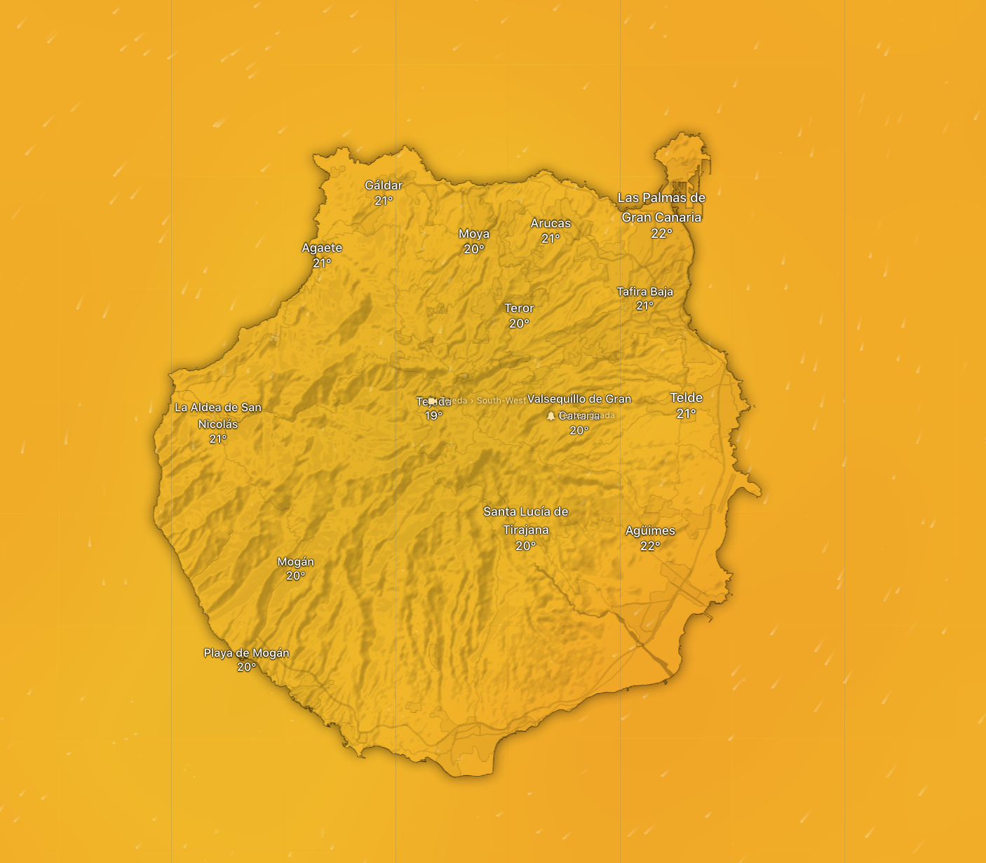
Maximum temperatures on Gran Canaria will not likely exceed 21º C, in the shade, while the rest of the islands hover around 23º. According to AEMET data, for those who are already aclimatised a good coat may be necessary for walks up at the island’s summits: with minimum temperatures of around 10ºC, while in coastal areas, maximums will not likely surpass 19º, in the shade.
As ever, most of the sunshine is expected on the south of the island, in the touristed resort areas of Maspalomas and Puerto Rico de Gran Canaria, though with the autumn change finally occurring there is no guarantee of constant heat, though if you do get blue skies, rememmber that sun can still burn.
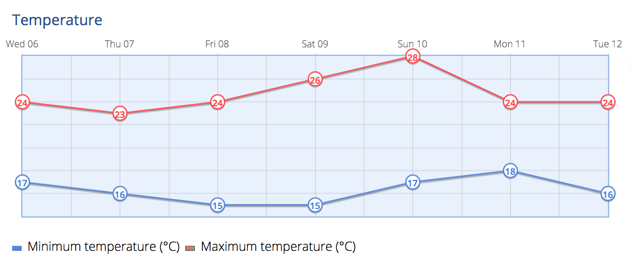
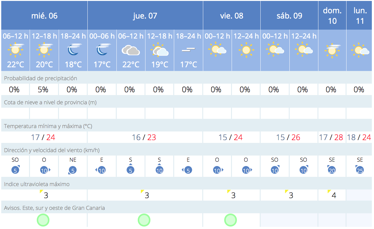
The weather on Gran Canaria this December 6, 2023, is expected to be overcast throughout the day in most places. The temperature in the afternoon is set to be around 23°C, perhaps feeling slightly warmer due to humidity. The wind speed is steady at around 10 kmph. As the evening progresses, temperatures are expected to gradually decrease, reaching around 68°F (20°C) by midnight. No significant precipitation is forecasted, with only a slight chance of rain in the morning of December 7th
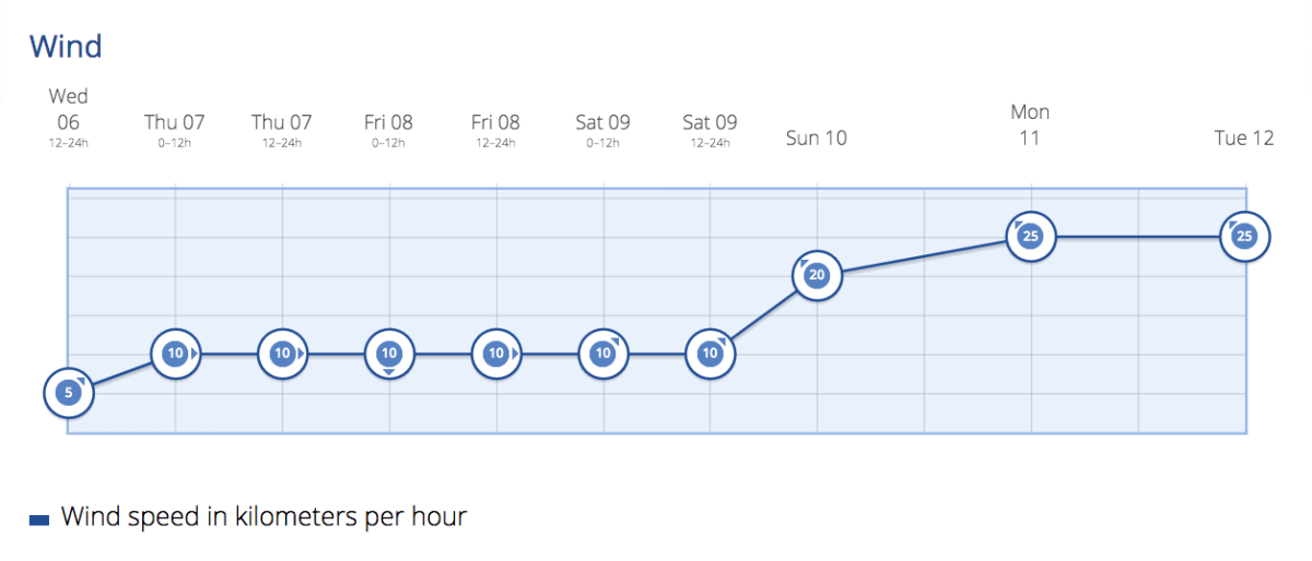
On Thursday Gran Canaria can expect a day of intermittent cloudy intervals. There is a slight chance of weak and occasional rain during the first half of the day, particularly on the eastern slopes of the island, though most predictions discount this. Temperatures should remain fairly steady, with no significant changes anticipated. Throughout the day, the island will experience a light to moderate northeast wind, which is expected to intensify by the evening. Particularly on the northwest and southeast slopes, there may be periods of stronger winds. At higher altitudes, the wind will be gentle and from the northeast. Some Calima is expected to arrive with us ahead of the weekend.
Friday morning will start with cloudy intervals, which are predicted to give way to clearer skies as the day progresses, except in the north of the more mountainous islands. Maximum temperatures may see a slight increase in the central islands, while minimum temperatures are expected to remain stable. A moderate northeast wind will prevail throughout the day.
For Saturday the general forecast for the day is mostly clear skies, with some intervals of clouds on the northern slopes of the island. Temperatures are set to experience a slight increase. The northeast wind will be moderate, but there are expected intervals of strong winds on the northwest and southeast slopes of the islands, as well as in the interiors of the lower lying Lanzarote and Fuerteventura.
By Sunday Gran Canaria is expected to enjoy mostly clear skies. No significant changes in the weather patterns are anticipated for the day. A gentle easterly wind will be present across all the islands. Temperatures across the south of Gran Canaria look set to rise to the upper 20s, perhaps hotter in direct sunlight.
As always, it’s recommended to wear sunscreen in direct sunlight, where temperatures can be a good 5-10º higher than the ambient temperature measured in the shade.
(by Windy)
(by Windy)
Courtesy of AEMET