While this winter in Spain has been marked by a drought, with fewer rainstorms than would usually be expected, thanks to an anti-cyclonic weather system over the Iberian peninsula, here in the Canary Islands, following a fairly dry year, even by the standards of the archipelago, significant rains and even snowfalls have occasionally arrived in recent weeks, on a few days combining low pressure with strong winds, Calima followed by warmer than usual days. According to Meteored, this Monday, it was possible that the DANA (high altitude depression, known as a cold drop) affecting the islands over recent days might well have “bounced” towards the Peninsula.
Feature Image: AEMET
|
----- Google provide a way for you to
|


Wednesday prediction – Courtesy of Windy
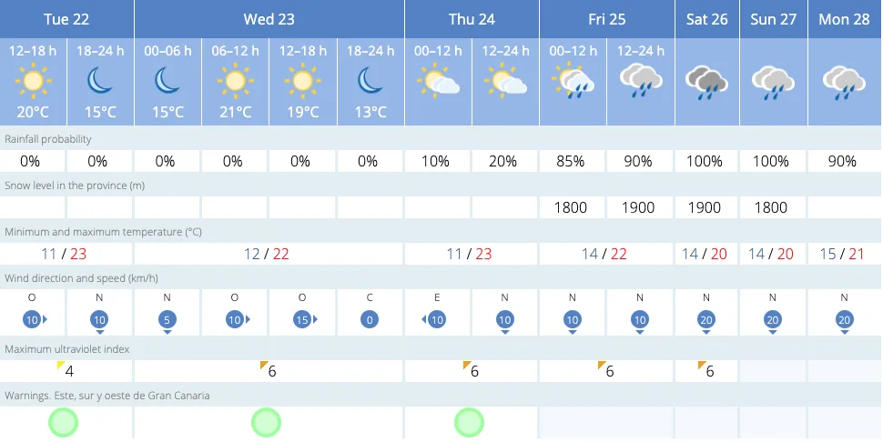
Since the weekend various places around the Archipelago have seen downpours and even some snow on the summits, interrupted by Calim on Tuesday, mainly affecting the eastern islands. Spanish State Meteorological Agency (AEMET) has also predicted a rise in temperatures.

Weather forecast for this Wednesday in the Canary Islands. / Image: AEMET

However, with a cold night on Monday, producing temperatures around freezing point on the summits of Gran Canaria, and daytime temperatures in the shade this Tuesday climbing towards the mid-20s (hotter in direct sunlight), this Wednesday is expected to produce further downpours, particularly on the north of the islands, according to the AEMET prediction, based on probabilistic prediction models from the ECMWF the European Centre for Medium-Range Weather Forecasts.
So strong rains are expected on Lanzarote and Fuerteventura, as well as the north of Tenerife, La Palma, La Gomera, and Gran Canaria.

Rainfall forecast for this Thursday in the Canary Islands. / Image: AEMET
On Thursday the rainfall will move towards the western islands and Gran Canaria, where rains are expected especially in the northern municipalities.
The south of Gran Canaria however has seen a climb in temperatures this Tuesday, with bright blue cloudless skies across the island, and warmer than average sunshine, which, with luck, could last until at least the end of the week, however, the rains are predicted, starting on Friday, to reach even the usually sunny beaches of Mogán and Maspalomas by the weekend.

 There is even some potential for thunderstorms by Monday, however, winds will be generally light, with some stronger gusts up on the northeast, and the majority of any precipitation limited mainly to the north. The dropping temperatures at the weekend, along with cloud and rain, could produce a light dusting of snow on the summits of Gran Canaria, however, the majority of any snow we are likely to see will be from a distance, looking out from Arguineguín, for instance, towards Mount Teide, which has already received a good covering of snow to start the week, with more likely to arrive by the weekend.

There is a lot of uncertainty as we approach this weekend, with meteorologists concluding, in statements published by CanariasAhora, “Today it seems … this pocket of cold air will be forced to head back towards the Canary Islands, where they are having more wintery and variable weather this winter than on the Peninsula itself”.