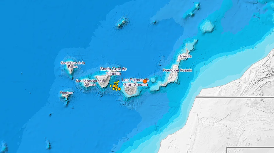
 Last Sunday the earth beneath the Canaries archipelago began to shake as a series of more than 50 earthquakes and tremors started to rumble under the sea, as they have for the last 2 days now, primarily focused on the channel that lies between Gran Canaria and Tenerife. The waters separating the eastern islands of Fuerteventura and Gran Canaria, however, were where the largest quake so far in this latest series was recorded just after 6am on Monday morning, measuring 3.2 on the Richter scale, at a depth of just 8km below the earth’s outer crust, and about 35km east of the Puerto La Luz, Port of Las Palmas de Gran Canaria.
Most of the seismic activity since has occurred closest to the Tenerife coast and during the early hours of Monday morning, the three most powerful tremors having reached between 2 & 2.2 on the Richter scale. These tremors are relatively minor and have not been felt by the population, in fact such instances are actually quite frequent in the Canary Islands region and its waters.
According to the director of the National Seismic Network from Spain’s N ational Geographic Institute (IGN – Instituto Geográfico Nacional), Emilio Carreño, the majority of earthquakes registered in the Canary Islands are of tectonic origin, and “are not usually associated with volcanology” or the volcanic activity that originally formed the archipelago, he said “it is not unusual”.

“Right now in the Peninsula there are quite a few places at which these series are being observed, it is common during any single month to register between 100 and 600 earthquakes in areas like in the Jódar area, or in Jaén, which can experience between 400 and 500 at the same time” he stressed.
Carreño pointed out that all earthquakes are reviewed, especially those in the Canary Islands because “the situation of the islands makes precision in locating the source more difficult”, and he finished by saying that the reviews are done both by the Seismic Network and from within the Volcanology Group.